Buhovo elevation
Buhovo (Sofia-Capital, Stolichna Obshtina), Bulgaria elevation is 702 meters and Buhovo elevation in feet is 2303 ft above sea level [src 1]. Buhovo is a populated place (feature code) with elevation that is 383 meters (1257 ft) bigger than average city elevation in Bulgaria.
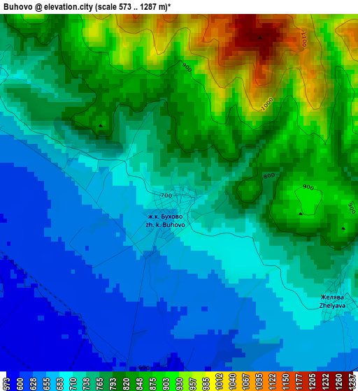
Below is the Elevation map of Buhovo, which displays elevation range with different colors. Scale of the first map is from 573 to 1287 m (1880 to 4222 ft) with average elevation of 764.9 meters (=2510 ft) [note 1]
These maps also provides idea of topography and contour of this city, they are displayed at different zoom levels. More info about maps, scale and edge coordinates you can find below images.
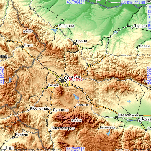
| \ | Map #1 | Topo.Map |
| Scale [m] | 573..1287 m | × |
| Scale [ft] | 1880..4222 ft | × |
| Average | 764.9 m = 2510 ft | × |
| Width | 7.17 km = 4.5 mi | 229.6 km = 142.7 mi |
| Height | 7.17 km = 4.5 mi | 229.6 km = 142.7 mi |
| ↑Max Latitude | 42.798923° | 43.79042° |
| Latitude at center | 42.76667° | 42.76667° |
| ↓Min Latitude | 42.7344° | 41.72571° |
| ← Min Longitude | 23.522725° | 22.16042° |
| Longitude center | 23.56667° | 23.56667° |
| →Max Longitude | 23.610615° | 24.97292° |
Nearby cities:
Cities around Buhovo sort by population:
• Sofia elevation 562 m
21.2 km,  248°
248°
• Botevgrad 363 m
23.1 km,  49°
49°
• Kostinbrod 534 m
29.1 km,  281°
281°
• Etropole 535 m
36.1 km,  78°
78°
• Svoge 455 m
28.4 km,  321°
321°
• Elin Pelin 549 m
11.4 km,  166°
166°
• Pravets 519 m
31.4 km,  65°
65°
• Bozhurishte 568 m
30 km,  266°
266°
• Mirkovo 725 m
34.8 km,  102°
102°
• Gorna Malina 647 m
14.3 km,  130°
130°
• Lakatnik 811 m
34.3 km,  336°
336°
• Bov 818 m
33.3 km,  332°
332°
Multilingual:
 En español:
Buhovo elevación 702 m.
 En France:
Buhovo élévation 702 m.


Sources and notes:
- [note 1] Map square and city borders are not equal. Map elevation data is calculated only from area inside that square.
- [src 1] Elevation data from geonames database provided with same terms of usage.
- [src 2] The elevation map of Buhovo is generated using elevation data from NASA's 3 arcsec (90m) resolution SRTM data.
- [src 3] Base (background) map © OpenStreetMap contributors tiles are generated by Geofabrik and OpenTopoMap.
Copyright & License:
This Buhovo Elevation Map is licensed under CC BY-SA. You may reuse any part from this page, if you give a proper credit by linking to this URL:
 More info on terms of use page.