Pernik elevation
Pernik, Bulgaria elevation is 712 meters and Pernik elevation in feet is 2336 ft above sea level [src 1]. Pernik is a seat of a first-order administrative division (feature code) with elevation that is 393 meters (1289 ft) bigger than average city elevation in Bulgaria.
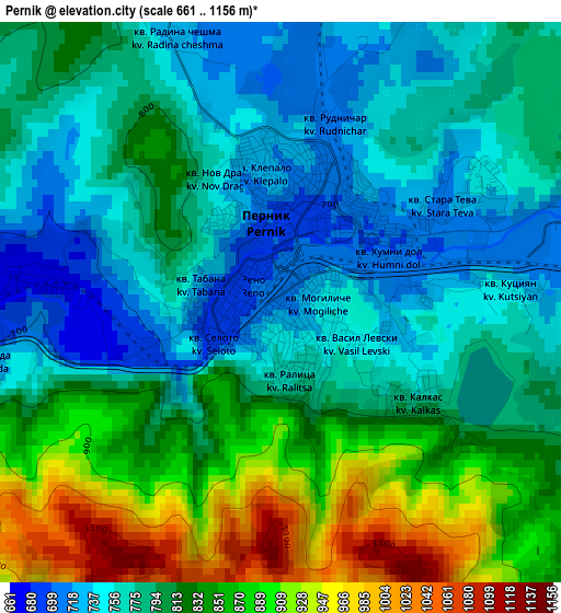
Below is the Elevation map of Pernik, which displays elevation range with different colors. Scale of the first map is from 661 to 1156 m (2169 to 3793 ft) with average elevation of 807 meters (=2648 ft) [note 1]
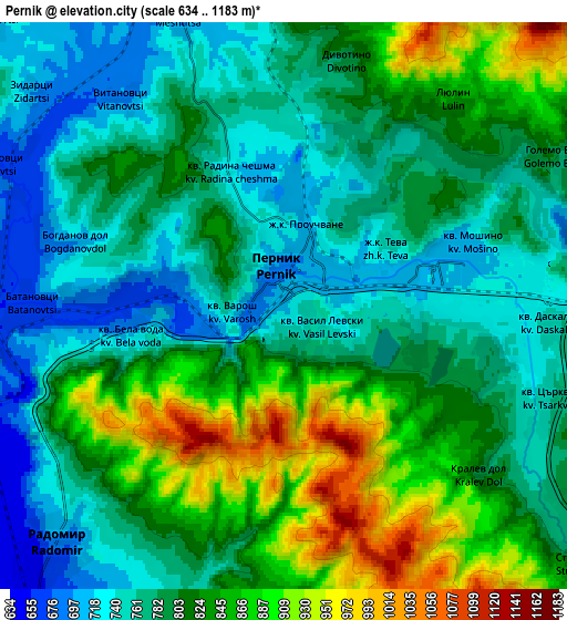
These maps also provides idea of topography and contour of this city, they are displayed at different zoom levels. More info about maps, scale and edge coordinates you can find below images.
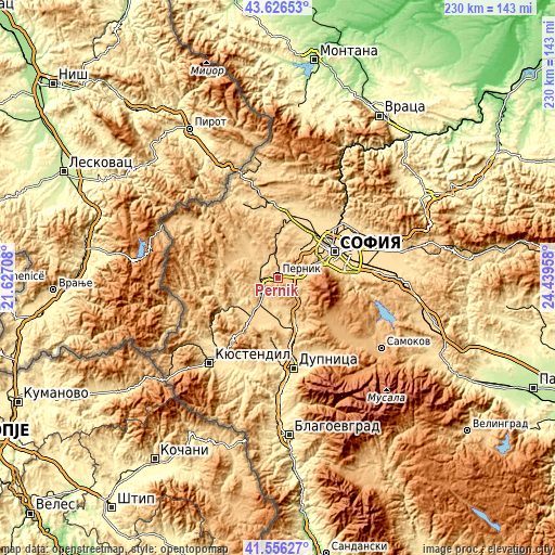
| \ | Map #1 | Map #2 | Topo.Map |
| Scale [m] | 661..1156 m | 634..1183 m | × |
| Scale [ft] | 2169..3793 ft | 2080..3881 ft | × |
| Average | 807 m = 2648 ft | 803.7 m = 2637 ft | × |
| Width | 7.19 km = 4.5 mi | 14.39 km = 8.9 mi | 230.2 km = 143 mi |
| Height | 7.19 km = 4.5 mi | 14.39 km = 8.9 mi | 230.2 km = 143 mi |
| ↑Max Latitude | 42.63234° | 42.664662° | 43.62653° |
| Latitude at center | 42.6° | 42.6° | 42.6° |
| ↓Min Latitude | 42.567644° | 42.53527° | 41.55627° |
| ← Min Longitude | 22.989385° | 22.945439° | 21.62708° |
| Longitude center | 23.03333° | 23.03333° | 23.03333° |
| →Max Longitude | 23.077275° | 23.121221° | 24.43958° |
Nearby cities:
Cities around Pernik sort by population:
• Sofia elevation 562 m
26.1 km,  65°
65°
• Dupnitsa 512 m
37.7 km,  169°
169°
• Radomir 683 m
8.2 km,  222°
222°
• Kostinbrod 534 m
28.4 km,  31°
31°
• Slivnitsa 591 m
28 km,  0°
0°
• Bobov Dol 648 m
26.5 km,  185°
185°
• Sapareva Banya 855 m
40.1 km,  151°
151°
• Bozhurishte 568 m
21.5 km,  39°
39°
• Breznik 757 m
18.7 km,  326°
326°
• Dragoman 723 m
36.8 km,  346°
346°
• Batanovtsi 661 m
6.3 km,  266°
266°
• Zemen 600 m
26.9 km,  239°
239°
Multilingual:
 En español:
Pernik elevación 712 m.
 En France:
Pernik élévation 712 m.


Sources and notes:
- [note 1] Map square and city borders are not equal. Map elevation data is calculated only from area inside that square.
- [src 1] Elevation data from geonames database provided with same terms of usage.
- [src 2] The elevation map of Pernik is generated using elevation data from NASA's 3 arcsec (90m) resolution SRTM data.
- [src 3] Base (background) map © OpenStreetMap contributors tiles are generated by Geofabrik and OpenTopoMap.
Copyright & License:
This Pernik Elevation Map is licensed under CC BY-SA. You may reuse any part from this page, if you give a proper credit by linking to this URL:
 More info on terms of use page.