Smyadovo elevation
Smyadovo (Shumen, Obshtina Smyadovo), Bulgaria elevation is 86 meters and Smyadovo elevation in feet is 282 ft above sea level [src 1]. Smyadovo is a populated place (feature code) with elevation that is 233 meters (764 ft) smaller than average city elevation in Bulgaria.
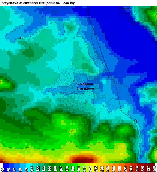
Below is the Elevation map of Smyadovo, which displays elevation range with different colors. Scale of the first map is from 54 to 348 m (177 to 1142 ft) with average elevation of 121.9 meters (=400 ft) [note 1]
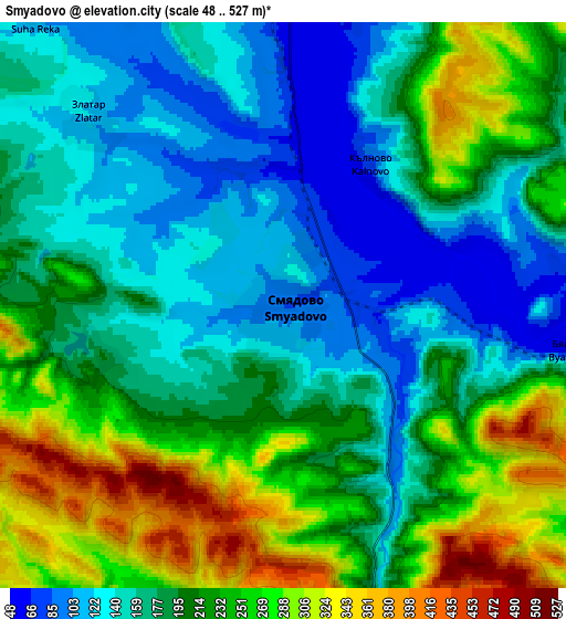
These maps also provides idea of topography and contour of this city, they are displayed at different zoom levels. More info about maps, scale and edge coordinates you can find below images.
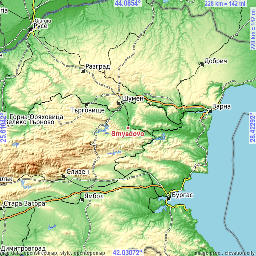
| \ | Map #1 | Map #2 | Topo.Map |
| Scale [m] | 54..348 m | 48..527 m | × |
| Scale [ft] | 177..1142 ft | 157..1729 ft | × |
| Average | 121.9 m = 400 ft | 200.1 m = 656 ft | × |
| Width | 7.14 km = 4.4 mi | 14.28 km = 8.9 mi | 228.5 km = 142 mi |
| Height | 7.14 km = 4.4 mi | 14.28 km = 8.9 mi | 228.5 km = 142 mi |
| ↑Max Latitude | 43.098766° | 43.130846° | 44.0854° |
| Latitude at center | 43.06667° | 43.06667° | 43.06667° |
| ↓Min Latitude | 43.034557° | 43.002427° | 42.03072° |
| ← Min Longitude | 26.972725° | 26.928779° | 25.61042° |
| Longitude center | 27.01667° | 27.01667° | 27.01667° |
| →Max Longitude | 27.060615° | 27.104561° | 28.42292° |
Nearby cities:
Cities around Smyadovo sort by population:
• Shumen elevation 237 m
23.9 km,  341°
341°
• Targovishte 186 m
41.5 km,  299°
299°
• Provadia 173 m
36.2 km,  69°
69°
• Novi Pazar 135 m
34.8 km,  25°
25°
• Veliki Preslav 146 m
19.7 km, 304°
• Dalgopol 34 m
27.1 km,  93°
93°
• Sungurlare 206 m
38.4 km,  209°
209°
• Varbitsa 279 m
32 km,  256°
256°
• Kaspichan 95 m
30.3 km,  23°
23°
• Ruen 205 m
36.7 km,  143°
143°
• Pliska 160 m
34.3 km,  13°
13°
• Kiten 219 m
24.4 km, 85°
Multilingual:
 En español:
Smyadovo elevación 86 m.
 En France:
Smyadovo élévation 86 m.


Sources and notes:
- [note 1] Map square and city borders are not equal. Map elevation data is calculated only from area inside that square.
- [src 1] Elevation data from geonames database provided with same terms of usage.
- [src 2] The elevation map of Smyadovo is generated using elevation data from NASA's 3 arcsec (90m) resolution SRTM data.
- [src 3] Base (background) map © OpenStreetMap contributors tiles are generated by Geofabrik and OpenTopoMap.
Copyright & License:
This Smyadovo Elevation Map is licensed under CC BY-SA. You may reuse any part from this page, if you give a proper credit by linking to this URL:
 More info on terms of use page.