Déou elevation
Déou (Sahel, Province de l’Oudalan), Burkina Faso elevation is 327 meters and Déou elevation in feet is 1073 ft above sea level [src 1]. Déou is a seat of a third-order administrative division (feature code) with elevation that is 23 meters (75 ft) bigger than average city elevation in Burkina Faso.
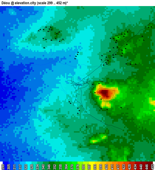
Below is the Elevation map of Déou, which displays elevation range with different colors. Scale of the first map is from 299 to 452 m (981 to 1483 ft) with average elevation of 333.5 meters (=1094 ft) [note 1]
These maps also provides idea of topography and contour of this city, they are displayed at different zoom levels. More info about maps, scale and edge coordinates you can find below images.
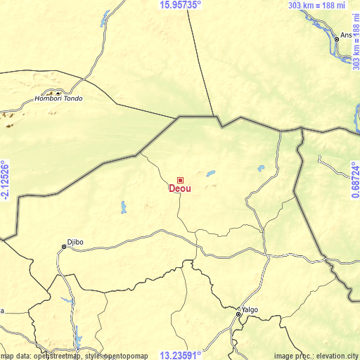
| \ | Map #1 | Topo.Map |
| Scale [m] | 299..452 m | × |
| Scale [ft] | 981..1483 ft | × |
| Average | 333.5 m = 1094 ft | × |
| Width | 9.46 km = 5.9 mi | 302.6 km = 188 mi |
| Height | 9.46 km = 5.9 mi | 302.6 km = 188 mi |
| ↑Max Latitude | 14.643362° | 15.95735° |
| Latitude at center | 14.60084° | 14.60084° |
| ↓Min Latitude | 14.55831° | 13.23591° |
| ← Min Longitude | -0.762955° | -2.12526° |
| Longitude center | -0.71901° | -0.71901° |
| →Max Longitude | -0.675065° | 0.68724° |
Nearby cities:
Cities around Déou sort by population:
• Kaya elevation 341 m
172.4 km,  193°
193°
• Dori 282 m
96.9 km,  130°
130°
• Kongoussi 330 m
166.9 km,  211°
211°
• Djibo 301 m
112.4 km,  240°
240°
• Titao 326 m
172.4 km, 237°
• Bogandé 287 m
191.4 km,  161°
161°
• Gorom-Gorom 274 m
55 km,  108°
108°
• Mané 258 m
191.6 km,  200°
200°
• Sebba 252 m
186.9 km, 133°
• Mani 264 m
158.9 km, 159°
• Tin-Akoff 248 m
72.2 km,  55°
55°
• Oursi 298 m
29 km,  73°
73°
Multilingual:
 En español:
Déou elevación 327 m.
 En France:
Déou élévation 327 m.


Sources and notes:
- [note 1] Map square and city borders are not equal. Map elevation data is calculated only from area inside that square.
- [src 1] Elevation data from geonames database provided with same terms of usage.
- [src 2] The elevation map of Déou is generated using elevation data from NASA's 3 arcsec (90m) resolution SRTM data.
- [src 3] Base (background) map © OpenStreetMap contributors tiles are generated by Geofabrik and OpenTopoMap.
Copyright & License:
This Déou Elevation Map is licensed under CC BY-SA. You may reuse any part from this page, if you give a proper credit by linking to this URL:
 More info on terms of use page.