Gorom-Gorom elevation
Gorom-Gorom (Sahel, Province de l’Oudalan), Burkina Faso elevation is 274 meters and Gorom-Gorom elevation in feet is 899 ft above sea level [src 1]. Gorom-Gorom is a seat of a second-order administrative division (feature code) with elevation that is 30 meters (98 ft) smaller than average city elevation in Burkina Faso.
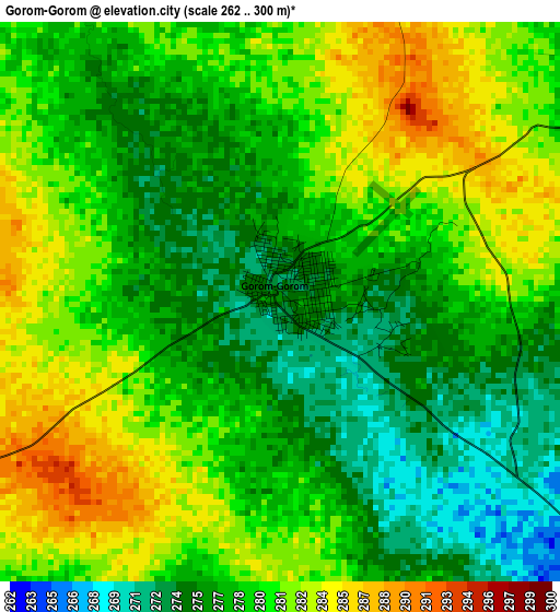
Below is the Elevation map of Gorom-Gorom, which displays elevation range with different colors. Scale of the first map is from 262 to 300 m (860 to 984 ft) with average elevation of 278.9 meters (=915 ft) [note 1]
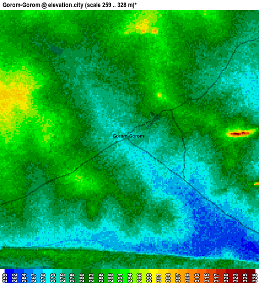
These maps also provides idea of topography and contour of this city, they are displayed at different zoom levels. More info about maps, scale and edge coordinates you can find below images.
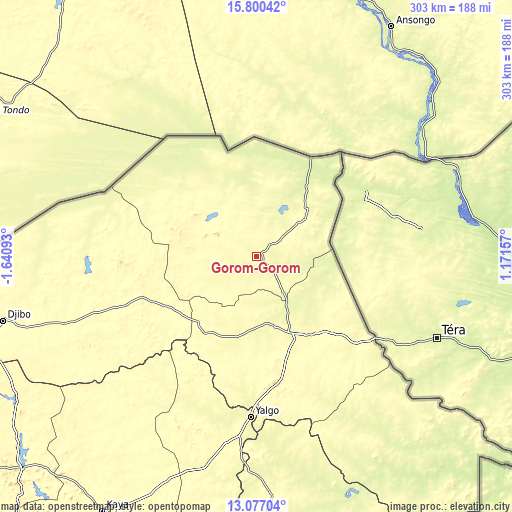
| \ | Map #1 | Map #2 | Topo.Map |
| Scale [m] | 262..300 m | 259..328 m | × |
| Scale [ft] | 860..984 ft | 850..1076 ft | × |
| Average | 278.9 m = 915 ft | 280.1 m = 919 ft | × |
| Width | 9.46 km = 5.9 mi | 18.93 km = 11.8 mi | 302.8 km = 188.2 mi |
| Height | 9.46 km = 5.9 mi | 18.93 km = 11.8 mi | 302.8 km = 188.2 mi |
| ↑Max Latitude | 14.485452° | 14.527997° | 15.80042° |
| Latitude at center | 14.4429° | 14.4429° | 14.4429° |
| ↓Min Latitude | 14.400339° | 14.357771° | 13.07704° |
| ← Min Longitude | -0.278625° | -0.322571° | -1.64093° |
| Longitude center | -0.23468° | -0.23468° | -0.23468° |
| →Max Longitude | -0.190735° | -0.146789° | 1.17157° |
Nearby cities:
Cities around Gorom-Gorom sort by population:
• Kaya elevation 341 m
176.1 km,  211°
211°
• Dori 282 m
50.2 km,  154°
154°
• Kongoussi 330 m
187.4 km,  228°
228°
• Djibo 301 m
154.7 km,  255°
255°
• Bogandé 287 m
164 km,  176°
176°
• Boussouma 301 m
193.4 km, 208°
• Boundoré 233 m
166.1 km,  132°
132°
• Sebba 252 m
139.1 km,  143°
143°
• Mani 264 m
131.7 km, 178°
• Tin-Akoff 248 m
58.6 km,  7°
7°
• Déou 327 m
55 km,  288°
288°
• Oursi 298 m
35.5 km,  316°
316°
Multilingual:
 En español:
Gorom-Gorom elevación 274 m.
 En France:
Gorom-Gorom élévation 274 m.
 Auf Deutsch:
Gorom-Gorom höhe über dem Meeresspiegel ist 274 m.

Sources and notes:
- [note 1] Map square and city borders are not equal. Map elevation data is calculated only from area inside that square.
- [src 1] Elevation data from geonames database provided with same terms of usage.
- [src 2] The elevation map of Gorom-Gorom is generated using elevation data from NASA's 3 arcsec (90m) resolution SRTM data.
- [src 3] Base (background) map © OpenStreetMap contributors tiles are generated by Geofabrik and OpenTopoMap.
Copyright & License:
This Gorom-Gorom Elevation Map is licensed under CC BY-SA. You may reuse any part from this page, if you give a proper credit by linking to this URL:
 More info on terms of use page.