Charleroi elevation
Charleroi (Wallonia, Province du Hainaut), Belgium elevation is 136 meters and Charleroi elevation in feet is 446 ft above sea level [src 1]. Charleroi is a populated place (feature code) with elevation that is 37 meters (121 ft) bigger than average city elevation in Belgium.
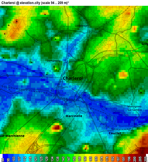
Below is the Elevation map of Charleroi, which displays elevation range with different colors. Scale of the first map is from 94 to 209 m (308 to 686 ft) with average elevation of 131.5 meters (=431 ft) [note 1]
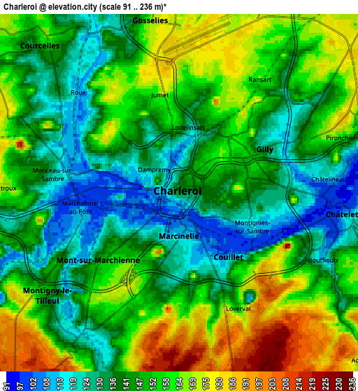
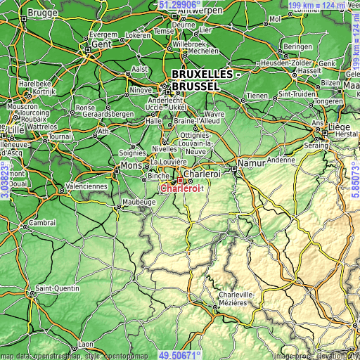
These maps also provides idea of topography and contour of this city, they are displayed at different zoom levels. More info about maps, scale and edge coordinates you can find below images.
| \ | Map #1 | Map #2 | Topo.Map |
| Scale [m] | 94..209 m | 91..236 m | × |
| Scale [ft] | 308..686 ft | 299..774 ft | × |
| Average | 131.5 m = 431 ft | 148.5 m = 487 ft | × |
| Width | 6.23 km = 3.9 mi | 12.46 km = 7.7 mi | 199.3 km = 123.8 mi |
| Height | 6.23 km = 3.9 mi | 12.46 km = 7.7 mi | 199.3 km = 123.8 mi |
| ↑Max Latitude | 50.439357° | 50.467337° | 51.29906° |
| Latitude at center | 50.41136° | 50.41136° | 50.41136° |
| ↓Min Latitude | 50.383347° | 50.355317° | 49.50671° |
| ← Min Longitude | 4.400535° | 4.356589° | 3.03823° |
| Longitude center | 4.44448° | 4.44448° | 4.44448° |
| →Max Longitude | 4.488425° | 4.532371° | 5.85073° |
Nearby cities:
Cities around Charleroi sort by population:
• Châtelet elevation 118 m
6 km,  98°
98°
• Courcelles 160 m
7.6 km,  319°
319°
• Fleurus 158 m
11 km,  42°
42°
• Pont-à-Celles 137 m
11.7 km,  332°
332°
• Thuin 156 m
13.8 km,  234°
234°
• Chapelle-lez-Herlaimont 165 m
13.3 km,  300°
300°
• Gerpinnes 185 m
10.1 km,  144°
144°
• Anderlues 181 m
12.3 km,  267°
267°
• Farciennes 128 m
7.2 km,  73°
73°
• Aiseau 117 m
10.1 km,  89°
89°
• La Bruyère 194 m
12.2 km, 98°
• Brunehault 147 m
10.5 km,  355°
355°
Multilingual:
 En español:
Charleroi elevación 136 m.
 En France:
Charleroi élévation 136 m.
 Auf Deutsch:
Charleroi höhe über dem Meeresspiegel ist 136 m.

Sources and notes:
- [note 1] Map square and city borders are not equal. Map elevation data is calculated only from area inside that square.
- [src 1] Elevation data from geonames database provided with same terms of usage.
- [src 2] The elevation map of Charleroi is generated using elevation data from NASA's 3 arcsec (90m) resolution SRTM data.
- [src 3] Base (background) map © OpenStreetMap contributors tiles are generated by Geofabrik and OpenTopoMap.
Copyright & License:
This Charleroi Elevation Map is licensed under CC BY-SA. You may reuse any part from this page, if you give a proper credit by linking to this URL:
 More info on terms of use page.