Chaudfontaine elevation
Chaudfontaine (Wallonia, Province de Liège), Belgium elevation is 218 meters and Chaudfontaine elevation in feet is 715 ft above sea level [src 1]. Chaudfontaine is a populated place (feature code) with elevation that is 119 meters (390 ft) bigger than average city elevation in Belgium.
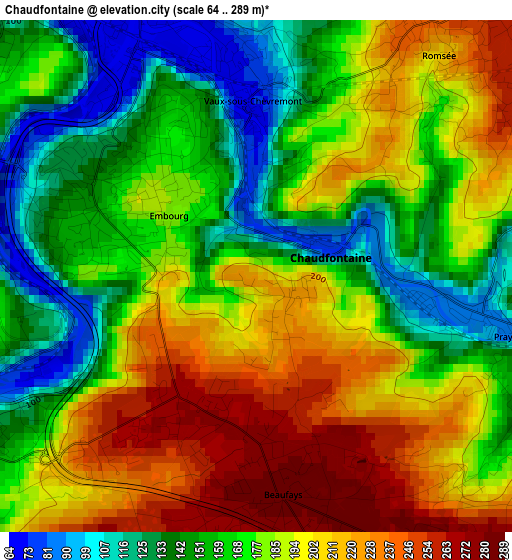
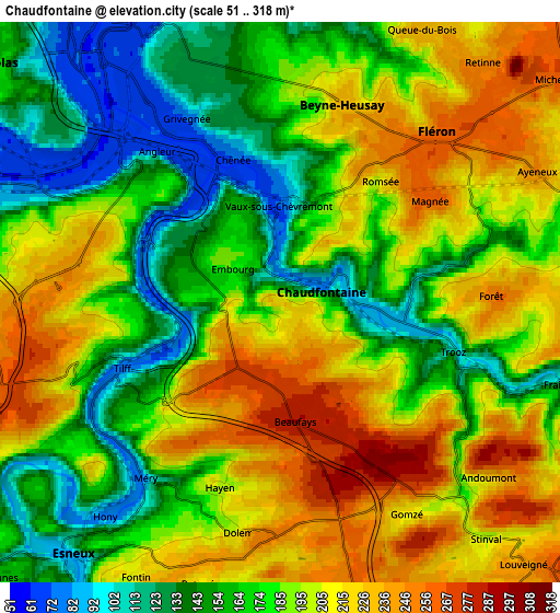
Below is the Elevation map of Chaudfontaine, which displays elevation range with different colors. Scale of the first map is from 64 to 289 m (210 to 948 ft) with average elevation of 179.4 meters (=589 ft) [note 1]
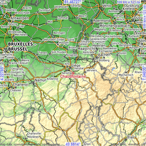
These maps also provides idea of topography and contour of this city, they are displayed at different zoom levels. More info about maps, scale and edge coordinates you can find below images.
| \ | Map #1 | Map #2 | Topo.Map |
| Scale [m] | 64..289 m | 51..318 m | × |
| Scale [ft] | 210..948 ft | 167..1043 ft | × |
| Average | 179.4 m = 589 ft | 186.3 m = 611 ft | × |
| Width | 6.21 km = 3.9 mi | 12.41 km = 7.7 mi | 198.6 km = 123.4 mi |
| Height | 6.21 km = 3.9 mi | 12.41 km = 7.7 mi | 198.6 km = 123.4 mi |
| ↑Max Latitude | 50.610695° | 50.638574° | 51.46727° |
| Latitude at center | 50.5828° | 50.5828° | 50.5828° |
| ↓Min Latitude | 50.554888° | 50.52696° | 49.6814° |
| ← Min Longitude | 5.590155° | 5.546209° | 4.22785° |
| Longitude center | 5.6341° | 5.6341° | 5.6341° |
| →Max Longitude | 5.678045° | 5.721991° | 7.04035° |
Nearby cities:
Cities around Chaudfontaine sort by population:
• Liège elevation 66 m
7.4 km,  320°
320°
• Seraing 185 m
9.4 km,  270°
270°
• Herstal 81 m
9.1 km,  355°
355°
• Saint-Nicolas 96 m
8.8 km,  305°
305°
• Fléron 258 m
4.9 km,  42°
42°
• Soumagne 200 m
8.7 km,  66°
66°
• Esneux 115 m
7 km,  221°
221°
• Sprimont 224 m
8.4 km,  167°
167°
• Blégny 218 m
11.9 km,  32°
32°
• Beyne-Heusay 231 m
4.9 km, 26°
• Trooz 98 m
4.5 km,  107°
107°
• Olne 226 m
8 km,  84°
84°
Multilingual:
 En español:
Chaudfontaine elevación 218 m.
 En France:
Chaudfontaine élévation 218 m.
 Auf Deutsch:
Chaudfontaine höhe über dem Meeresspiegel ist 218 m.

Sources and notes:
- [note 1] Map square and city borders are not equal. Map elevation data is calculated only from area inside that square.
- [src 1] Elevation data from geonames database provided with same terms of usage.
- [src 2] The elevation map of Chaudfontaine is generated using elevation data from NASA's 3 arcsec (90m) resolution SRTM data.
- [src 3] Base (background) map © OpenStreetMap contributors tiles are generated by Geofabrik and OpenTopoMap.
Copyright & License:
This Chaudfontaine Elevation Map is licensed under CC BY-SA. You may reuse any part from this page, if you give a proper credit by linking to this URL:
 More info on terms of use page.