Huy elevation
Huy (Wallonia, Province de Liège), Belgium elevation is 75 meters and Huy elevation in feet is 246 ft above sea level [src 1]. Huy is a populated place (feature code) with elevation that is 24 meters (79 ft) smaller than average city elevation in Belgium.
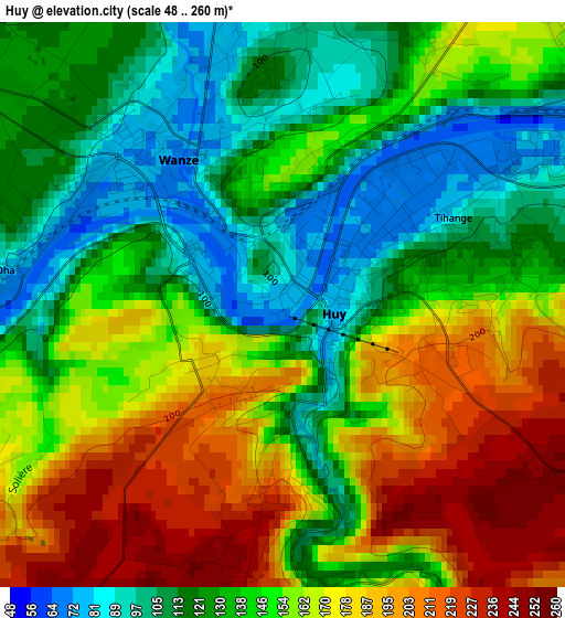
Below is the Elevation map of Huy, which displays elevation range with different colors. Scale of the first map is from 48 to 260 m (157 to 853 ft) with average elevation of 148.2 meters (=486 ft) [note 1]
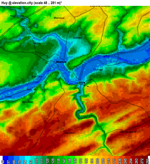
These maps also provides idea of topography and contour of this city, they are displayed at different zoom levels. More info about maps, scale and edge coordinates you can find below images.
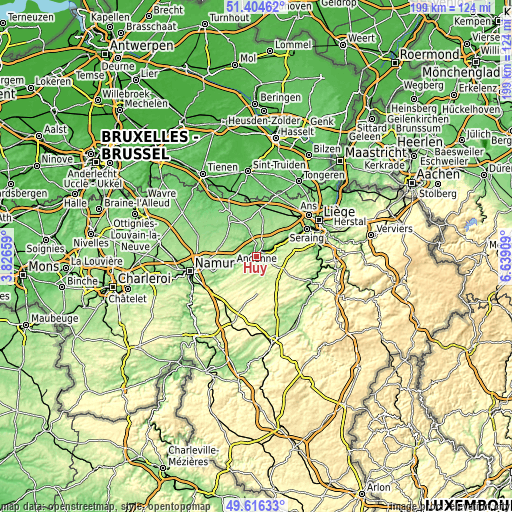
| \ | Map #1 | Map #2 | Topo.Map |
| Scale [m] | 48..260 m | 48..281 m | × |
| Scale [ft] | 157..853 ft | 157..922 ft | × |
| Average | 148.2 m = 486 ft | 173.1 m = 568 ft | × |
| Width | 6.21 km = 3.9 mi | 12.43 km = 7.7 mi | 198.8 km = 123.5 mi |
| Height | 6.21 km = 3.9 mi | 12.43 km = 7.7 mi | 198.8 km = 123.5 mi |
| ↑Max Latitude | 50.546873° | 50.57479° | 51.40462° |
| Latitude at center | 50.51894° | 50.51894° | 50.51894° |
| ↓Min Latitude | 50.49099° | 50.463024° | 49.61633° |
| ← Min Longitude | 5.188895° | 5.144949° | 3.82659° |
| Longitude center | 5.23284° | 5.23284° | 5.23284° |
| →Max Longitude | 5.276785° | 5.320731° | 6.63909° |
Nearby cities:
Cities around Huy sort by population:
• Andenne elevation 78 m
10.3 km,  251°
251°
• Amay 131 m
6.3 km,  59°
59°
• Wanze 96 m
2.8 km,  322°
322°
• Villers-le-Bouillet 194 m
6.7 km,  16°
16°
• Braives 123 m
13 km,  327°
327°
• Nandrin 218 m
13.2 km,  95°
95°
• Marchin 264 m
5.8 km,  173°
173°
• Ohey 269 m
12.1 km,  219°
219°
• Héron 165 m
10.1 km,  288°
288°
• Modave 229 m
9.2 km,  151°
151°
• Verlaine 171 m
11.5 km,  31°
31°
• Tinlot 271 m
11.3 km,  115°
115°
Multilingual:
 En español:
Huy elevación 75 m.
 En France:
Huy élévation 75 m.


Sources and notes:
- [note 1] Map square and city borders are not equal. Map elevation data is calculated only from area inside that square.
- [src 1] Elevation data from geonames database provided with same terms of usage.
- [src 2] The elevation map of Huy is generated using elevation data from NASA's 3 arcsec (90m) resolution SRTM data.
- [src 3] Base (background) map © OpenStreetMap contributors tiles are generated by Geofabrik and OpenTopoMap.
Copyright & License:
This Huy Elevation Map is licensed under CC BY-SA. You may reuse any part from this page, if you give a proper credit by linking to this URL:
 More info on terms of use page.