Héron elevation
Héron (Wallonia, Province de Liège), Belgium elevation is 165 meters and Héron elevation in feet is 541 ft above sea level [src 1]. Héron is a populated place (feature code) with elevation that is 66 meters (217 ft) bigger than average city elevation in Belgium.
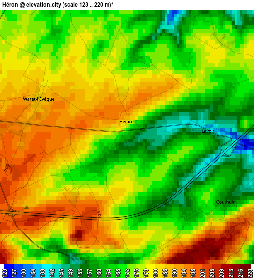
Below is the Elevation map of Héron, which displays elevation range with different colors. Scale of the first map is from 123 to 220 m (404 to 722 ft) with average elevation of 176 meters (=577 ft) [note 1]
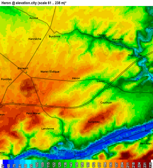
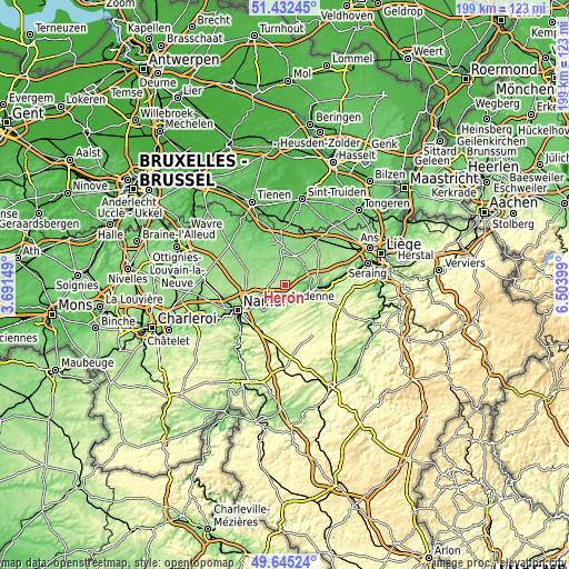
These maps also provides idea of topography and contour of this city, they are displayed at different zoom levels. More info about maps, scale and edge coordinates you can find below images.
| \ | Map #1 | Map #2 | Topo.Map |
| Scale [m] | 123..220 m | 61..238 m | × |
| Scale [ft] | 404..722 ft | 200..781 ft | × |
| Average | 176 m = 577 ft | 160.4 m = 526 ft | × |
| Width | 6.21 km = 3.9 mi | 12.42 km = 7.7 mi | 198.7 km = 123.5 mi |
| Height | 6.21 km = 3.9 mi | 12.42 km = 7.7 mi | 198.7 km = 123.5 mi |
| ↑Max Latitude | 50.575226° | 50.603126° | 51.43245° |
| Latitude at center | 50.54731° | 50.54731° | 50.54731° |
| ↓Min Latitude | 50.519377° | 50.491428° | 49.64524° |
| ← Min Longitude | 5.053795° | 5.009849° | 3.69149° |
| Longitude center | 5.09774° | 5.09774° | 5.09774° |
| →Max Longitude | 5.141685° | 5.185631° | 6.50399° |
Nearby cities:
Cities around Héron sort by population:
• Andenne elevation 78 m
6.4 km,  181°
181°
• Huy 75 m
10.1 km,  108°
108°
• Hannut 140 m
13.9 km,  354°
354°
• Wanze 96 m
7.9 km,  96°
96°
• Villers-le-Bouillet 194 m
11.9 km,  73°
73°
• Braives 123 m
8.2 km,  17°
17°
• Marchin 264 m
13.6 km,  131°
131°
• Ohey 269 m
12.5 km,  171°
171°
• Burdinne 167 m
4.4 km,  340°
340°
• Wasseiges 133 m
10.6 km,  321°
321°
• Noville-les-Bois 174 m
8.1 km,  277°
277°
• Forville 171 m
7.6 km,  293°
293°
Multilingual:
 En español:
Héron elevación 165 m.
 En France:
Héron élévation 165 m.


Sources and notes:
- [note 1] Map square and city borders are not equal. Map elevation data is calculated only from area inside that square.
- [src 1] Elevation data from geonames database provided with same terms of usage.
- [src 2] The elevation map of Héron is generated using elevation data from NASA's 3 arcsec (90m) resolution SRTM data.
- [src 3] Base (background) map © OpenStreetMap contributors tiles are generated by Geofabrik and OpenTopoMap.
Copyright & License:
This Héron Elevation Map is licensed under CC BY-SA. You may reuse any part from this page, if you give a proper credit by linking to this URL:
 More info on terms of use page.