Gračanica elevation
Gračanica (Federation of B&H), Bosnia and Herzegovina elevation is 1173 meters and Gračanica elevation in feet is 3848 ft above sea level [src 1]. Gračanica is a populated place (feature code) with elevation that is 810 meters (2657 ft) bigger than average city elevation in Bosnia and Herzegovina.
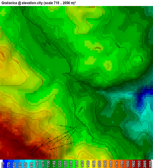
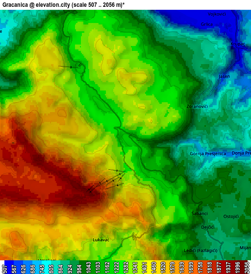
Below is the Elevation map of Gračanica, which displays elevation range with different colors. Scale of the first map is from 719 to 2056 m (2359 to 6745 ft) with average elevation of 1344.5 meters (=4411 ft) [note 1]
These maps also provides idea of topography and contour of this city, they are displayed at different zoom levels. More info about maps, scale and edge coordinates you can find below images.
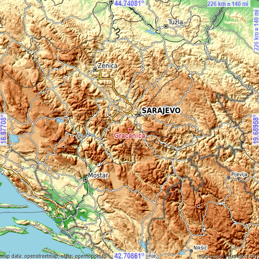
| \ | Map #1 | Map #2 | Topo.Map |
| Scale [m] | 719..2056 m | 507..2056 m | × |
| Scale [ft] | 2359..6745 ft | 1663..6745 ft | × |
| Average | 1344.5 m = 4411 ft | 1243.4 m = 4079 ft | × |
| Width | 7.06 km = 4.4 mi | 14.12 km = 8.8 mi | 226 km = 140.4 mi |
| Height | 7.06 km = 4.4 mi | 14.12 km = 8.8 mi | 226 km = 140.4 mi |
| ↑Max Latitude | 43.765075° | 43.796803° | 44.74081° |
| Latitude at center | 43.73333° | 43.73333° | 43.73333° |
| ↓Min Latitude | 43.701568° | 43.66979° | 42.70861° |
| ← Min Longitude | 18.239385° | 18.195439° | 16.87708° |
| Longitude center | 18.28333° | 18.28333° | 18.28333° |
| →Max Longitude | 18.327275° | 18.371221° | 19.68958° |
Nearby cities:
Cities around Gračanica sort by population:
• Sarajevo elevation 509 m
14.1 km,  24°
24°
• Vogošća 509 m
19.4 km,  14°
14°
• Hadžići 555 m
11.6 km,  328°
328°
• Pazarić 643 m
11.6 km,  302°
302°
• Hotonj 571 m
19.3 km, 23°
• Polje 566 m
23.4 km,  314°
314°
• Kobilja Glava 605 m
18.6 km,  27°
27°
• Kreševo 607 m
24.2 km, 307°
• Hreša 1063 m
23.5 km,  46°
46°
• Trnovo 817 m
15.1 km,  119°
119°
• Lukavica 546 m
13.1 km,  37°
37°
• Ilidža 497 m
10.8 km, 7°
Multilingual:
 En español:
Gračanica elevación 1173 m.
 En France:
Gračanica élévation 1173 m.
 Auf Deutsch:
Gračanica höhe über dem Meeresspiegel ist 1173 m.

Sources and notes:
- [note 1] Map square and city borders are not equal. Map elevation data is calculated only from area inside that square.
- [src 1] Elevation data from geonames database provided with same terms of usage.
- [src 2] The elevation map of Gračanica is generated using elevation data from NASA's 3 arcsec (90m) resolution SRTM data.
- [src 3] Base (background) map © OpenStreetMap contributors tiles are generated by Geofabrik and OpenTopoMap.
Copyright & License:
This Gračanica Elevation Map is licensed under CC BY-SA. You may reuse any part from this page, if you give a proper credit by linking to this URL:
 More info on terms of use page.