Rodoč elevation
Rodoč (Federation of B&H), Bosnia and Herzegovina elevation is 57 meters and Rodoč elevation in feet is 187 ft above sea level [src 1]. Rodoč is a populated locality (feature code) with elevation that is 306 meters (1004 ft) smaller than average city elevation in Bosnia and Herzegovina.
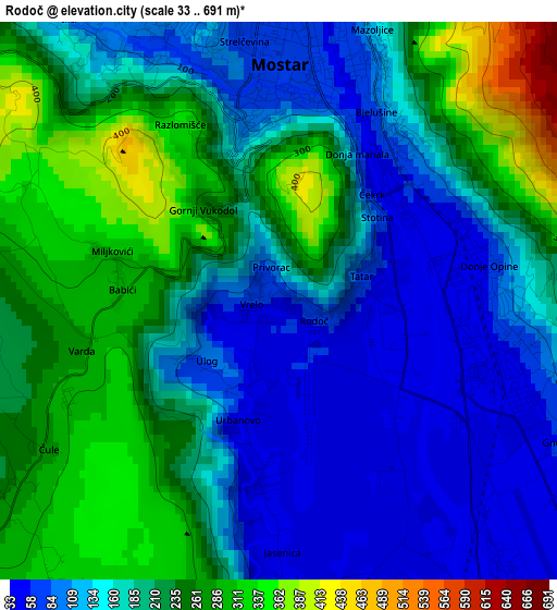
Below is the Elevation map of Rodoč, which displays elevation range with different colors. Scale of the first map is from 33 to 691 m (108 to 2267 ft) with average elevation of 188.7 meters (=619 ft) [note 1]
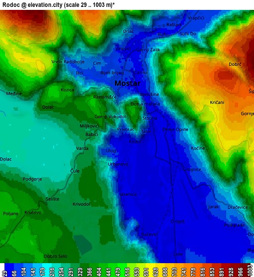
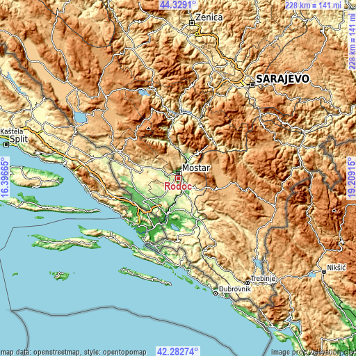
These maps also provides idea of topography and contour of this city, they are displayed at different zoom levels. More info about maps, scale and edge coordinates you can find below images.
| \ | Map #1 | Map #2 | Topo.Map |
| Scale [m] | 33..691 m | 29..1003 m | × |
| Scale [ft] | 108..2267 ft | 95..3291 ft | × |
| Average | 188.7 m = 619 ft | 304.5 m = 999 ft | × |
| Width | 7.11 km = 4.4 mi | 14.22 km = 8.8 mi | 227.5 km = 141.4 mi |
| Height | 7.11 km = 4.4 mi | 14.22 km = 8.8 mi | 227.5 km = 141.4 mi |
| ↑Max Latitude | 43.346496° | 43.378445° | 44.3291° |
| Latitude at center | 43.31453° | 43.31453° | 43.31453° |
| ↓Min Latitude | 43.282547° | 43.250547° | 42.28274° |
| ← Min Longitude | 17.758955° | 17.715009° | 16.39665° |
| Longitude center | 17.8029° | 17.8029° | 17.8029° |
| →Max Longitude | 17.846845° | 17.890791° | 19.20915° |
Nearby cities:
Cities around Rodoč sort by population:
• Mostar elevation 66 m
3.2 km,  7°
7°
• Ljubuški 95 m
24.6 km,  237°
237°
• Široki Brijeg 281 m
18.5 km,  294°
294°
• Potoci 91 m
12.2 km,  30°
30°
• Čapljina 38 m
23.5 km,  204°
204°
• Crnići 239 m
20.9 km,  166°
166°
• Čitluk 225 m
12.6 km,  220°
220°
• Blagaj 62 m
9.3 km,  131°
131°
• Radišići 182 m
23.6 km, 244°
• Cim 142 m
4.8 km,  337°
337°
• Ilići 98 m
4.6 km,  322°
322°
• Tasovčići 17 m
23.4 km, 196°
Multilingual:
 En español:
Rodoč elevación 57 m.
 En France:
Rodoč élévation 57 m.


Sources and notes:
- [note 1] Map square and city borders are not equal. Map elevation data is calculated only from area inside that square.
- [src 1] Elevation data from geonames database provided with same terms of usage.
- [src 2] The elevation map of Rodoč is generated using elevation data from NASA's 3 arcsec (90m) resolution SRTM data.
- [src 3] Base (background) map © OpenStreetMap contributors tiles are generated by Geofabrik and OpenTopoMap.
Copyright & License:
This Rodoč Elevation Map is licensed under CC BY-SA. You may reuse any part from this page, if you give a proper credit by linking to this URL:
 More info on terms of use page.