Sanica elevation
Sanica (Federation of B&H), Bosnia and Herzegovina elevation is 204 meters and Sanica elevation in feet is 669 ft above sea level [src 1]. Sanica is a populated place (feature code) with elevation that is 159 meters (522 ft) smaller than average city elevation in Bosnia and Herzegovina.
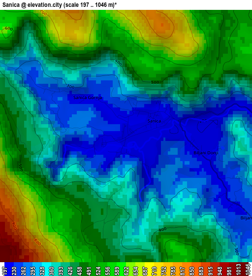
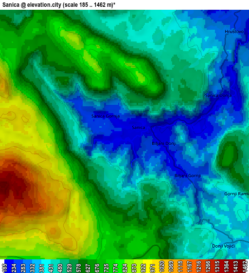
Below is the Elevation map of Sanica, which displays elevation range with different colors. Scale of the first map is from 197 to 1046 m (646 to 3432 ft) with average elevation of 424 meters (=1391 ft) [note 1]
These maps also provides idea of topography and contour of this city, they are displayed at different zoom levels. More info about maps, scale and edge coordinates you can find below images.
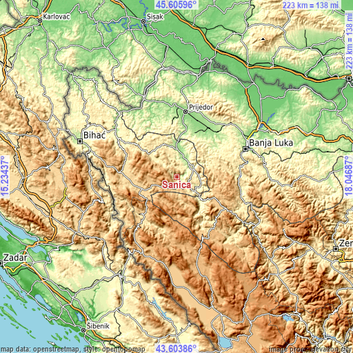
| \ | Map #1 | Map #2 | Topo.Map |
| Scale [m] | 197..1046 m | 185..1462 m | × |
| Scale [ft] | 646..3432 ft | 607..4797 ft | × |
| Average | 424 m = 1391 ft | 578 m = 1896 ft | × |
| Width | 6.96 km = 4.3 mi | 13.91 km = 8.6 mi | 222.6 km = 138.3 mi |
| Height | 6.96 km = 4.3 mi | 13.91 km = 8.6 mi | 222.6 km = 138.3 mi |
| ↑Max Latitude | 44.644814° | 44.676072° | 45.60596° |
| Latitude at center | 44.61354° | 44.61354° | 44.61354° |
| ↓Min Latitude | 44.582249° | 44.55094° | 43.60386° |
| ← Min Longitude | 16.596675° | 16.552729° | 15.23437° |
| Longitude center | 16.64062° | 16.64062° | 16.64062° |
| →Max Longitude | 16.684565° | 16.728511° | 18.04687° |
Nearby cities:
Cities around Sanica sort by population:
• Sanski Most elevation 158 m
17.2 km,  6°
6°
• Ključ 258 m
14.1 km,  129°
129°
• Velagići 350 m
9.7 km, 130°
• Bronzani Majdan 275 m
30.9 km,  49°
49°
• Marićka 152 m
33 km,  30°
30°
• Peći 365 m
11.4 km,  79°
79°
• Bosanski Petrovac 673 m
22.5 km,  253°
253°
• Drvar 492 m
33.7 km,  217°
217°
• Oštra Luka 268 m
27.5 km,  3°
3°
• Gornji Ribnik 311 m
25.9 km,  147°
147°
• Potoci 1041 m
24.6 km,  183°
183°
• Drinić 723 m
18.2 km,  229°
229°
Multilingual:
 En español:
Sanica elevación 204 m.
 En France:
Sanica élévation 204 m.


Sources and notes:
- [note 1] Map square and city borders are not equal. Map elevation data is calculated only from area inside that square.
- [src 1] Elevation data from geonames database provided with same terms of usage.
- [src 2] The elevation map of Sanica is generated using elevation data from NASA's 3 arcsec (90m) resolution SRTM data.
- [src 3] Base (background) map © OpenStreetMap contributors tiles are generated by Geofabrik and OpenTopoMap.
Copyright & License:
This Sanica Elevation Map is licensed under CC BY-SA. You may reuse any part from this page, if you give a proper credit by linking to this URL:
 More info on terms of use page.