Hobart city centre elevation
Hobart city centre (Tasmania, Hobart), Australia elevation is 20 meters and Hobart city centre elevation in feet is 66 ft above sea level [src 1]. Hobart city centre is a section of populated place (feature code) with elevation that is 93 meters (305 ft) smaller than average city elevation in Australia.
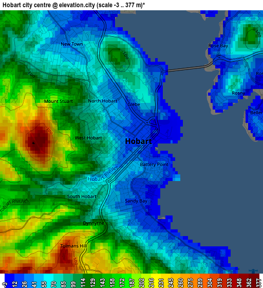
Below is the Elevation map of Hobart city centre, which displays elevation range with different colors. Scale of the first map is from -3 to 377 m (-10 to 1237 ft) with average elevation of 107.8 meters (=354 ft) [note 1]
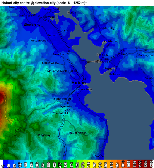
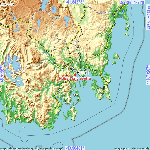
These maps also provides idea of topography and contour of this city, they are displayed at different zoom levels. More info about maps, scale and edge coordinates you can find below images.
| \ | Map #1 | Map #2 | Topo.Map |
| Scale [m] | -3..377 m | -8..1252 m | × |
| Scale [ft] | -10..1237 ft | -26..4108 ft | × |
| Average | 107.8 m = 354 ft | 187.6 m = 615 ft | × |
| Width | 7.16 km = 4.4 mi | 14.32 km = 8.9 mi | 229.1 km = 142.4 mi |
| Height | 7.16 km = 4.4 mi | 14.32 km = 8.9 mi | 229.1 km = 142.4 mi |
| ↑Max Latitude | -42.850591° | -42.818365° | -41.84378° |
| Latitude at center | -42.8828° | -42.8828° | -42.8828° |
| ↓Min Latitude | -42.914992° | -42.947168° | -43.90461° |
| ← Min Longitude | 147.281875° | 147.237929° | 145.91957° |
| Longitude center | 147.32582° | 147.32582° | 147.32582° |
| →Max Longitude | 147.369765° | 147.413711° | 148.73207° |
Nearby cities:
Cities around Hobart city centre sort by population:
• Hobart elevation 1 m
0.5 km,  37°
37°
• Sandy Bay 27 m
1.3 km,  185°
185°
• New Town 44 m
3.1 km,  333°
333°
• Lenah Valley 209 m
4.3 km,  286°
286°
• West Hobart 97 m
1.7 km, 294°
• South Hobart 69 m
1.9 km,  225°
225°
• Bellerive 13 m
3.7 km,  77°
77°
• North Hobart 54 m
1.3 km,  320°
320°
• Mount Nelson 289 m
4.2 km, 185°
• Mount Stuart 165 m
2.3 km,  302°
302°
• Battery Point 34 m
1 km,  142°
142°
• Dynnyrne 139 m
2.6 km,  198°
198°
Multilingual:
 En español:
Hobart city centre elevación 20 m.
 En France:
Hobart city centre élévation 20 m.
 Auf Deutsch:
Hobart city centre höhe über dem Meeresspiegel ist 20 m.

Sources and notes:
- [note 1] Map square and city borders are not equal. Map elevation data is calculated only from area inside that square.
- [src 1] Elevation data from geonames database provided with same terms of usage.
- [src 2] The elevation map of Hobart city centre is generated using elevation data from NASA's 3 arcsec (90m) resolution SRTM data.
- [src 3] Base (background) map © OpenStreetMap contributors tiles are generated by Geofabrik and OpenTopoMap.
Copyright & License:
This Hobart city centre Elevation Map is licensed under CC BY-SA. You may reuse any part from this page, if you give a proper credit by linking to this URL:
 More info on terms of use page.