Hobart elevation
Hobart (Tasmania), Australia elevation is 1 meters and Hobart elevation in feet is 3 ft above sea level [src 1]. Hobart is a seat of a first-order administrative division (feature code) with elevation that is 112 meters (367 ft) smaller than average city elevation in Australia.
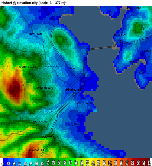
Below is the Elevation map of Hobart, which displays elevation range with different colors. Scale of the first map is from -3 to 377 m (-10 to 1237 ft) with average elevation of 89.8 meters (=295 ft) [note 1]
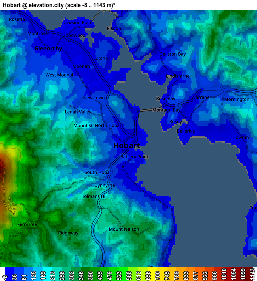
These maps also provides idea of topography and contour of this city, they are displayed at different zoom levels. More info about maps, scale and edge coordinates you can find below images.
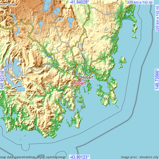
| \ | Map #1 | Map #2 | Topo.Map |
| Scale [m] | -3..377 m | -8..1143 m | × |
| Scale [ft] | -10..1237 ft | -26..3750 ft | × |
| Average | 89.8 m = 295 ft | 174.6 m = 573 ft | × |
| Width | 7.16 km = 4.4 mi | 14.32 km = 8.9 mi | 229.2 km = 142.4 mi |
| Height | 7.16 km = 4.4 mi | 14.32 km = 8.9 mi | 229.1 km = 142.4 mi |
| ↑Max Latitude | -42.847149° | -42.814921° | -41.84028° |
| Latitude at center | -42.87936° | -42.87936° | -42.87936° |
| ↓Min Latitude | -42.911554° | -42.943732° | -43.90123° |
| ← Min Longitude | 147.285465° | 147.241519° | 145.92316° |
| Longitude center | 147.32941° | 147.32941° | 147.32941° |
| →Max Longitude | 147.373355° | 147.417301° | 148.73566° |
Nearby cities:
Cities around Hobart sort by population:
• Sandy Bay elevation 27 m
1.7 km,  193°
193°
• New Town 44 m
3 km,  325°
325°
• Lindisfarne 17 m
4.3 km,  37°
37°
• West Hobart 97 m
1.9 km,  279°
279°
• Moonah 32 m
4.3 km, 329°
• South Hobart 69 m
2.4 km,  224°
224°
• Bellerive 13 m
3.4 km,  82°
82°
• Hobart city centre 20 m
0.5 km, 217°
• North Hobart 54 m
1.2 km,  298°
298°
• Mount Stuart 165 m
2.4 km,  290°
290°
• Battery Point 34 m
1.2 km,  165°
165°
• Dynnyrne 139 m
3.1 km,  201°
201°
Multilingual:
 En español:
Hobart elevación 1 m.
 En France:
Hobart élévation 1 m.


Sources and notes:
- [note 1] Map square and city borders are not equal. Map elevation data is calculated only from area inside that square.
- [src 1] Elevation data from geonames database provided with same terms of usage.
- [src 2] The elevation map of Hobart is generated using elevation data from NASA's 3 arcsec (90m) resolution SRTM data.
- [src 3] Base (background) map © OpenStreetMap contributors tiles are generated by Geofabrik and OpenTopoMap.
Copyright & License:
This Hobart Elevation Map is licensed under CC BY-SA. You may reuse any part from this page, if you give a proper credit by linking to this URL:
 More info on terms of use page.