Keilor East elevation
Keilor East (Victoria, Moonee Valley), Australia elevation is 68 meters and Keilor East elevation in feet is 223 ft above sea level [src 1]. Keilor East is a section of populated place (feature code) with elevation that is 45 meters (148 ft) smaller than average city elevation in Australia.
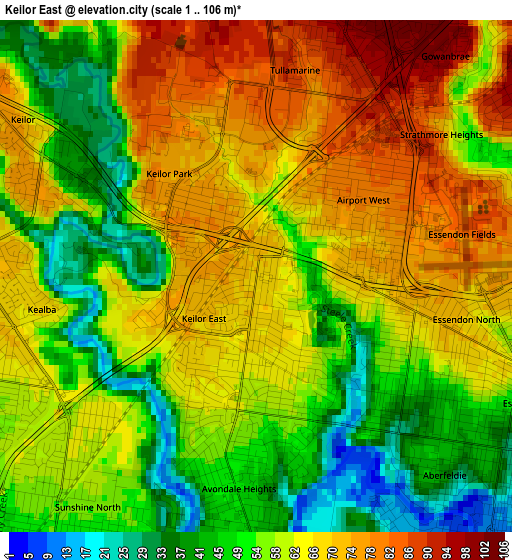
Below is the Elevation map of Keilor East, which displays elevation range with different colors. Scale of the first map is from 1 to 106 m (3 to 348 ft) with average elevation of 59.9 meters (=197 ft) [note 1]
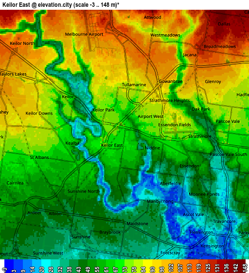
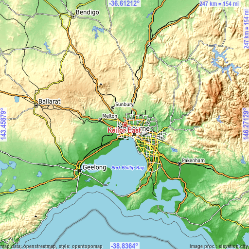
These maps also provides idea of topography and contour of this city, they are displayed at different zoom levels. More info about maps, scale and edge coordinates you can find below images.
| \ | Map #1 | Map #2 | Topo.Map |
| Scale [m] | 1..106 m | -3..148 m | × |
| Scale [ft] | 3..348 ft | -10..486 ft | × |
| Average | 59.9 m = 197 ft | 67 m = 220 ft | × |
| Width | 7.73 km = 4.8 mi | 15.46 km = 9.6 mi | 247.3 km = 153.7 mi |
| Height | 7.73 km = 4.8 mi | 15.46 km = 9.6 mi | 247.3 km = 153.7 mi |
| ↑Max Latitude | -37.697847° | -37.663067° | -36.61212° |
| Latitude at center | -37.73261° | -37.73261° | -37.73261° |
| ↓Min Latitude | -37.767357° | -37.802088° | -38.8364° |
| ← Min Longitude | 144.821095° | 144.777149° | 143.45879° |
| Longitude center | 144.86504° | 144.86504° | 144.86504° |
| →Max Longitude | 144.908985° | 144.952931° | 146.27129° |
Nearby cities:
Cities around Keilor East sort by population:
• Essendon elevation 47 m
4.5 km,  115°
115°
• Avondale Heights 48 m
3.2 km,  183°
183°
• Airport West 77 m
1.7 km,  58°
58°
• Tullamarine 96 m
3.8 km,  21°
21°
• Keilor 38 m
3.3 km,  302°
302°
• Niddrie 70 m
2.4 km,  102°
102°
• Aberfeldie 33 m
4.1 km,  136°
136°
• Kealba 66 m
3.3 km,  261°
261°
• Essendon North 65 m
3.7 km,  106°
106°
• Gowanbrae 90 m
3.5 km,  39°
39°
• Keilor Park 74 m
1.7 km,  325°
325°
• Essendon West 9 m
3 km,  146°
146°
Multilingual:
 En español:
Keilor East elevación 68 m.
 En France:
Keilor East élévation 68 m.
 Auf Deutsch:
Keilor East höhe über dem Meeresspiegel ist 68 m.

Sources and notes:
- [note 1] Map square and city borders are not equal. Map elevation data is calculated only from area inside that square.
- [src 1] Elevation data from geonames database provided with same terms of usage.
- [src 2] The elevation map of Keilor East is generated using elevation data from NASA's 3 arcsec (90m) resolution SRTM data.
- [src 3] Base (background) map © OpenStreetMap contributors tiles are generated by Geofabrik and OpenTopoMap.
Copyright & License:
This Keilor East Elevation Map is licensed under CC BY-SA. You may reuse any part from this page, if you give a proper credit by linking to this URL:
 More info on terms of use page.