Keilor elevation
Keilor (Victoria, Brimbank), Australia elevation is 38 meters and Keilor elevation in feet is 125 ft above sea level [src 1]. Keilor is a section of populated place (feature code) with elevation that is 75 meters (246 ft) smaller than average city elevation in Australia.
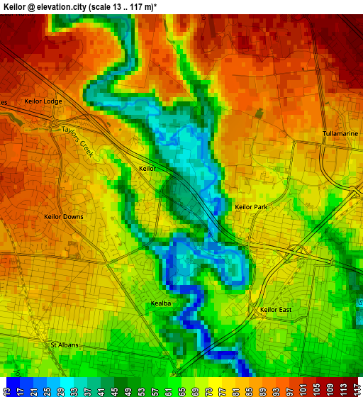
Below is the Elevation map of Keilor, which displays elevation range with different colors. Scale of the first map is from 13 to 117 m (43 to 384 ft) with average elevation of 73.7 meters (=242 ft) [note 1]
These maps also provides idea of topography and contour of this city, they are displayed at different zoom levels. More info about maps, scale and edge coordinates you can find below images.
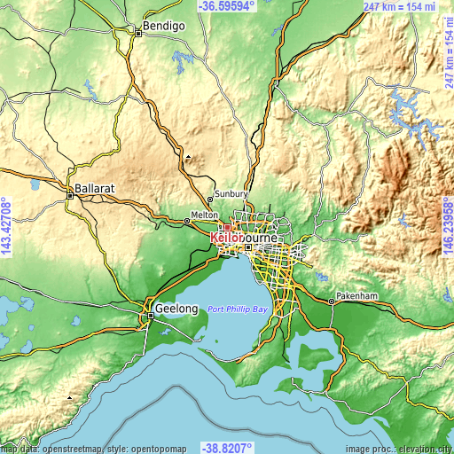
| \ | Map #1 | Map #2 | Topo.Map |
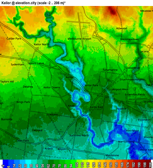
| Scale [m] | 13..117 m | -2..206 m | × |
| Scale [ft] | 43..384 ft | -7..676 ft | × |
| Average | 73.7 m = 242 ft | 80.8 m = 265 ft | × |
| Width | 7.73 km = 4.8 mi | 15.46 km = 9.6 mi | 247.4 km = 153.7 mi |
| Height | 7.73 km = 4.8 mi | 15.46 km = 9.6 mi | 247.4 km = 153.7 mi |
| ↑Max Latitude | -37.681899° | -37.647112° | -36.59594° |
| Latitude at center | -37.71667° | -37.71667° | -37.71667° |
| ↓Min Latitude | -37.751425° | -37.786163° | -38.8207° |
| ← Min Longitude | 144.789385° | 144.745439° | 143.42708° |
| Longitude center | 144.83333° | 144.83333° | 144.83333° |
| →Max Longitude | 144.877275° | 144.921221° | 146.23958° |
Nearby cities:
Cities around Keilor sort by population:
• St Albans elevation 70 m
4.3 km,  222°
222°
• Saint Albans 81 m
3.5 km,  237°
237°
• Taylors Lakes 99 m
4.6 km,  295°
295°
• Keilor East 68 m
3.3 km,  122°
122°
• Keilor Downs 83 m
2.3 km,  251°
251°
• Delahey 95 m
4.9 km,  265°
265°
• Airport West 77 m
4.3 km,  101°
101°
• Tullamarine 96 m
4.5 km,  67°
67°
• Kealba 66 m
2.3 km,  191°
191°
• Gowanbrae 90 m
5.1 km,  79°
79°
• Keilor Park 74 m
1.9 km, 102°
• Keilor Lodge 86 m
3.2 km,  305°
305°
Multilingual:
 En español:
Keilor elevación 38 m.
 En France:
Keilor élévation 38 m.


Sources and notes:
- [note 1] Map square and city borders are not equal. Map elevation data is calculated only from area inside that square.
- [src 1] Elevation data from geonames database provided with same terms of usage.
- [src 2] The elevation map of Keilor is generated using elevation data from NASA's 3 arcsec (90m) resolution SRTM data.
- [src 3] Base (background) map © OpenStreetMap contributors tiles are generated by Geofabrik and OpenTopoMap.
Copyright & License:
This Keilor Elevation Map is licensed under CC BY-SA. You may reuse any part from this page, if you give a proper credit by linking to this URL:
 More info on terms of use page.