Bundoora elevation
Bundoora (Victoria, Banyule), Australia elevation is 101 meters and Bundoora elevation in feet is 331 ft above sea level [src 1]. Bundoora is a section of populated place (feature code) with elevation that is 12 meters (39 ft) smaller than average city elevation in Australia.
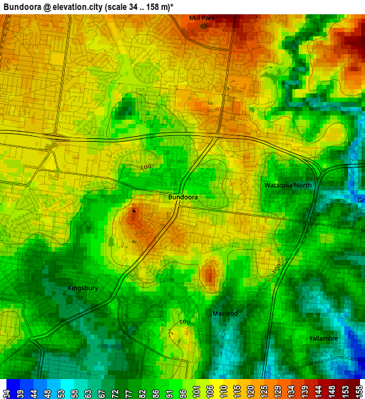
Below is the Elevation map of Bundoora, which displays elevation range with different colors. Scale of the first map is from 34 to 158 m (112 to 518 ft) with average elevation of 96.8 meters (=318 ft) [note 1]
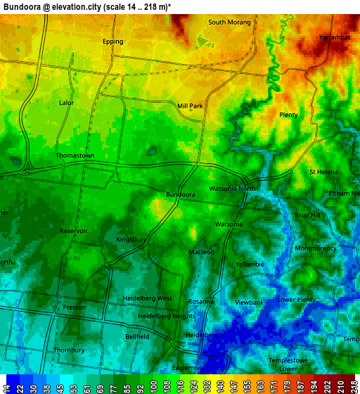
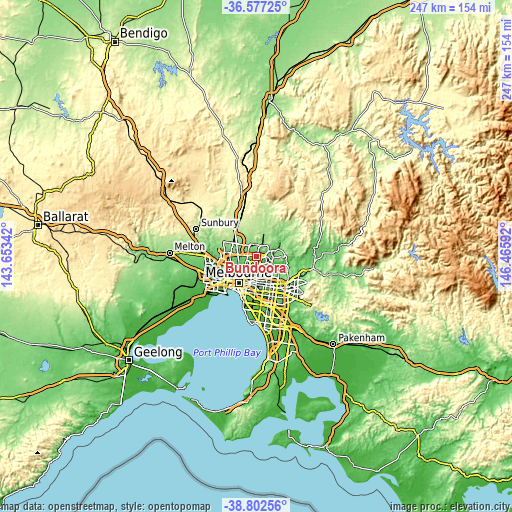
These maps also provides idea of topography and contour of this city, they are displayed at different zoom levels. More info about maps, scale and edge coordinates you can find below images.
| \ | Map #1 | Map #2 | Topo.Map |
| Scale [m] | 34..158 m | 14..218 m | × |
| Scale [ft] | 112..518 ft | 46..715 ft | × |
| Average | 96.8 m = 318 ft | 96.7 m = 317 ft | × |
| Width | 7.73 km = 4.8 mi | 15.46 km = 9.6 mi | 247.4 km = 153.7 mi |
| Height | 7.73 km = 4.8 mi | 15.46 km = 9.6 mi | 247.4 km = 153.7 mi |
| ↑Max Latitude | -37.66347° | -37.628675° | -36.57725° |
| Latitude at center | -37.69825° | -37.69825° | -37.69825° |
| ↓Min Latitude | -37.733013° | -37.76776° | -38.80256° |
| ← Min Longitude | 145.015725° | 144.971779° | 143.65342° |
| Longitude center | 145.05967° | 145.05967° | 145.05967° |
| →Max Longitude | 145.103615° | 145.147561° | 146.46592° |
Nearby cities:
Cities around Bundoora sort by population:
• Mill Park elevation 133 m
3.6 km,  9°
9°
• Lalor 123 m
5.2 km,  312°
312°
• Thomastown 113 m
4.1 km,  293°
293°
• Greensborough 75 m
3.9 km,  100°
100°
• Macleod 56 m
3.9 km,  171°
171°
• Rosanna 146 m
4.6 km, 171°
• Heidelberg Heights 85 m
5 km,  182°
182°
• Heidelberg West 63 m
4.9 km,  200°
200°
• Watsonia 91 m
2.9 km,  134°
134°
• Yallambie 78 m
4.2 km,  135°
135°
• Kingsbury 85 m
2.8 km,  230°
230°
• Watsonia North 88 m
2.2 km,  94°
94°
Multilingual:
 En español:
Bundoora elevación 101 m.
 En France:
Bundoora élévation 101 m.
 Auf Deutsch:
Bundoora höhe über dem Meeresspiegel ist 101 m.

Sources and notes:
- [note 1] Map square and city borders are not equal. Map elevation data is calculated only from area inside that square.
- [src 1] Elevation data from geonames database provided with same terms of usage.
- [src 2] The elevation map of Bundoora is generated using elevation data from NASA's 3 arcsec (90m) resolution SRTM data.
- [src 3] Base (background) map © OpenStreetMap contributors tiles are generated by Geofabrik and OpenTopoMap.
Copyright & License:
This Bundoora Elevation Map is licensed under CC BY-SA. You may reuse any part from this page, if you give a proper credit by linking to this URL:
 More info on terms of use page.