Bunya elevation
Bunya (Queensland, Moreton Bay), Australia elevation is 69 meters and Bunya elevation in feet is 226 ft above sea level [src 1]. Bunya is a section of populated place (feature code) with elevation that is 44 meters (144 ft) smaller than average city elevation in Australia.
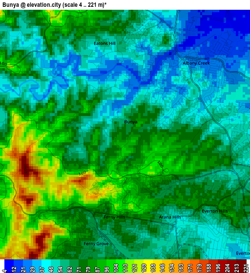
Below is the Elevation map of Bunya, which displays elevation range with different colors. Scale of the first map is from 4 to 221 m (13 to 725 ft) with average elevation of 70 meters (=230 ft) [note 1]
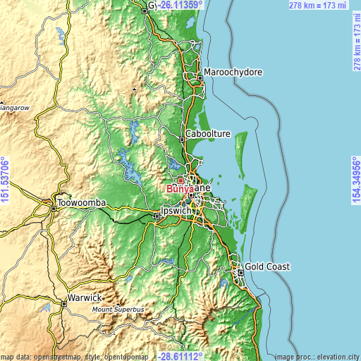
These maps also provides idea of topography and contour of this city, they are displayed at different zoom levels. More info about maps, scale and edge coordinates you can find below images.
| \ | Map #1 | Topo.Map |
| Scale [m] | 4..221 m | × |
| Scale [ft] | 13..725 ft | × |
| Average | 70 m = 230 ft | × |
| Width | 8.68 km = 5.4 mi | 277.7 km = 172.6 mi |
| Height | 8.68 km = 5.4 mi | 277.7 km = 172.6 mi |
| ↑Max Latitude | -27.330367° | -26.11359° |
| Latitude at center | -27.3694° | -27.3694° |
| ↓Min Latitude | -27.408419° | -28.61112° |
| ← Min Longitude | 152.899365° | 151.53706° |
| Longitude center | 152.94331° | 152.94331° |
| →Max Longitude | 152.987255° | 154.34956° |
Nearby cities:
Cities around Bunya sort by population:
• Albany Creek elevation 33 m
3 km,  54°
54°
• Everton Park 45 m
6.1 km,  133°
133°
• Ferny Hills 80 m
3 km,  191°
191°
• Mitchelton 69 m
5.7 km,  156°
156°
• Bridgeman Downs 46 m
5.3 km,  72°
72°
• Eatons Hill 39 m
3.7 km,  26°
26°
• McDowall 61 m
5 km,  107°
107°
• Keperra 66 m
4.9 km,  175°
175°
• Arana Hills 51 m
3.5 km, 155°
• Everton Hills 75 m
3.5 km, 128°
• Ferny Grove 60 m
3.6 km, 193°
• Upper Kedron 82 m
6 km,  204°
204°
Multilingual:
 En español:
Bunya elevación 69 m.
 En France:
Bunya élévation 69 m.


Sources and notes:
- [note 1] Map square and city borders are not equal. Map elevation data is calculated only from area inside that square.
- [src 1] Elevation data from geonames database provided with same terms of usage.
- [src 2] The elevation map of Bunya is generated using elevation data from NASA's 3 arcsec (90m) resolution SRTM data.
- [src 3] Base (background) map © OpenStreetMap contributors tiles are generated by Geofabrik and OpenTopoMap.
Copyright & License:
This Bunya Elevation Map is licensed under CC BY-SA. You may reuse any part from this page, if you give a proper credit by linking to this URL:
 More info on terms of use page.