Mitchelton elevation
Mitchelton (Queensland, Brisbane), Australia elevation is 69 meters and Mitchelton elevation in feet is 226 ft above sea level [src 1]. Mitchelton is a section of populated place (feature code) with elevation that is 44 meters (144 ft) smaller than average city elevation in Australia.
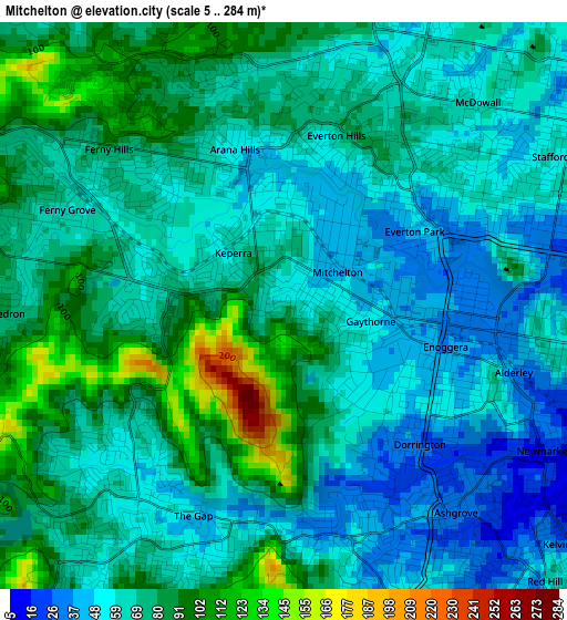
Below is the Elevation map of Mitchelton, which displays elevation range with different colors. Scale of the first map is from 5 to 284 m (16 to 932 ft) with average elevation of 70.3 meters (=231 ft) [note 1]
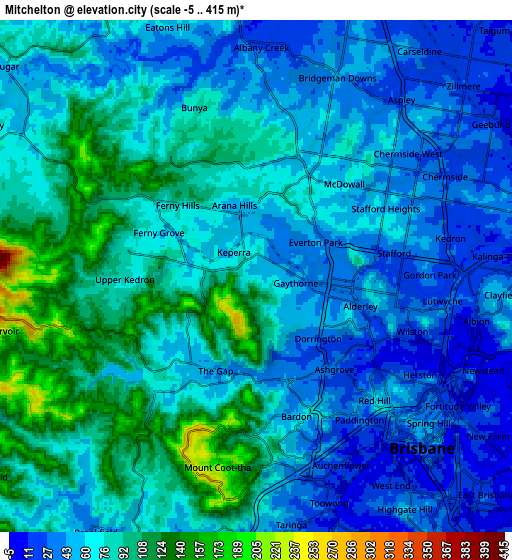
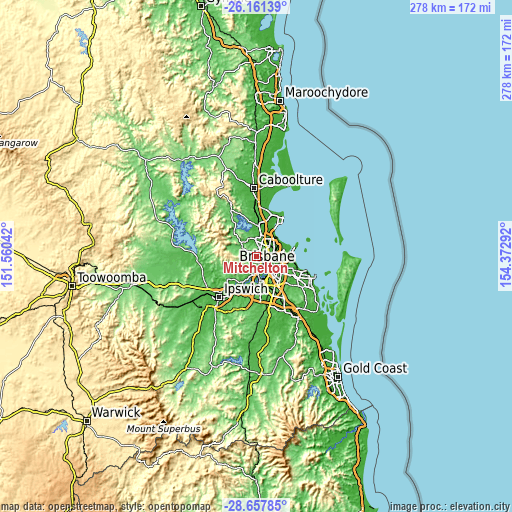
These maps also provides idea of topography and contour of this city, they are displayed at different zoom levels. More info about maps, scale and edge coordinates you can find below images.
| \ | Map #1 | Map #2 | Topo.Map |
| Scale [m] | 5..284 m | -5..415 m | × |
| Scale [ft] | 16..932 ft | -16..1362 ft | × |
| Average | 70.3 m = 231 ft | 68.1 m = 223 ft | × |
| Width | 8.67 km = 5.4 mi | 17.35 km = 10.8 mi | 277.6 km = 172.5 mi |
| Height | 8.67 km = 5.4 mi | 17.35 km = 10.8 mi | 277.6 km = 172.5 mi |
| ↑Max Latitude | -27.377654° | -27.338624° | -26.16139° |
| Latitude at center | -27.41667° | -27.41667° | -27.41667° |
| ↓Min Latitude | -27.455673° | -27.494661° | -28.65785° |
| ← Min Longitude | 152.922725° | 152.878779° | 151.56042° |
| Longitude center | 152.96667° | 152.96667° | 152.96667° |
| →Max Longitude | 153.010615° | 153.054561° | 154.37292° |
Nearby cities:
Cities around Mitchelton sort by population:
• The Gap elevation 64 m
3.9 km,  224°
224°
• Ashgrove 36 m
4.1 km,  142°
142°
• Everton Park 45 m
2.4 km,  64°
64°
• Ferny Hills 80 m
3.7 km,  308°
308°
• Keperra 66 m
2 km,  279°
279°
• Arana Hills 51 m
2.2 km,  337°
337°
• Stafford 24 m
4.4 km,  81°
81°
• Alderley 38 m
3.5 km,  106°
106°
• Everton Hills 75 m
3.1 km,  8°
8°
• Ferny Grove 60 m
3.6 km,  299°
299°
• Enoggera 55 m
1.5 km,  148°
148°
• Gaythorne 44 m
1.6 km,  90°
90°
Multilingual:
 En español:
Mitchelton elevación 69 m.
 En France:
Mitchelton élévation 69 m.
 Auf Deutsch:
Mitchelton höhe über dem Meeresspiegel ist 69 m.

Sources and notes:
- [note 1] Map square and city borders are not equal. Map elevation data is calculated only from area inside that square.
- [src 1] Elevation data from geonames database provided with same terms of usage.
- [src 2] The elevation map of Mitchelton is generated using elevation data from NASA's 3 arcsec (90m) resolution SRTM data.
- [src 3] Base (background) map © OpenStreetMap contributors tiles are generated by Geofabrik and OpenTopoMap.
Copyright & License:
This Mitchelton Elevation Map is licensed under CC BY-SA. You may reuse any part from this page, if you give a proper credit by linking to this URL:
 More info on terms of use page.