Alderley elevation
Alderley (Queensland, Brisbane), Australia elevation is 38 meters and Alderley elevation in feet is 125 ft above sea level [src 1]. Alderley is a section of populated place (feature code) with elevation that is 75 meters (246 ft) smaller than average city elevation in Australia.
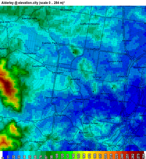
Below is the Elevation map of Alderley, which displays elevation range with different colors. Scale of the first map is from 0 to 284 m (0 to 932 ft) with average elevation of 46 meters (=151 ft) [note 1]
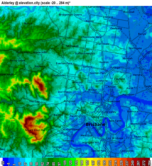
These maps also provides idea of topography and contour of this city, they are displayed at different zoom levels. More info about maps, scale and edge coordinates you can find below images.
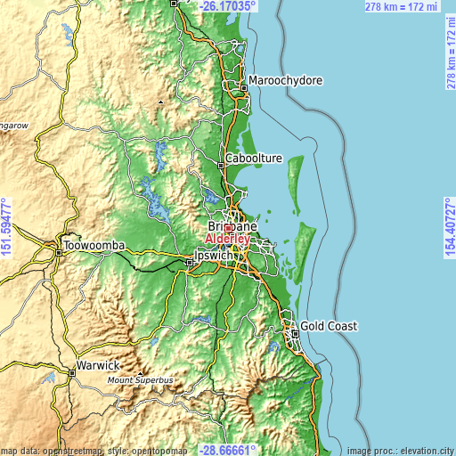
| \ | Map #1 | Map #2 | Topo.Map |
| Scale [m] | 0..284 m | -20..284 m | × |
| Scale [ft] | 0..932 ft | -66..932 ft | × |
| Average | 46 m = 151 ft | 47.9 m = 157 ft | × |
| Width | 8.67 km = 5.4 mi | 17.35 km = 10.8 mi | 277.6 km = 172.5 mi |
| Height | 8.67 km = 5.4 mi | 17.35 km = 10.8 mi | 277.6 km = 172.5 mi |
| ↑Max Latitude | -27.386517° | -27.34749° | -26.17035° |
| Latitude at center | -27.42553° | -27.42553° | -27.42553° |
| ↓Min Latitude | -27.464529° | -27.503515° | -28.66661° |
| ← Min Longitude | 152.957075° | 152.913129° | 151.59477° |
| Longitude center | 153.00102° | 153.00102° | 153.00102° |
| →Max Longitude | 153.044965° | 153.088911° | 154.40727° |
Nearby cities:
Cities around Alderley sort by population:
• Ashgrove elevation 36 m
2.4 km,  201°
201°
• Everton Park 45 m
2.4 km,  328°
328°
• Kelvin Grove 53 m
2.8 km,  154°
154°
• Windsor 29 m
3 km,  113°
113°
• Stafford 24 m
1.9 km,  30°
30°
• Enoggera 55 m
2.6 km,  263°
263°
• Newmarket 17 m
1.3 km, 148°
• Grange 32 m
1.4 km,  76°
76°
• Gordon Park 29 m
2.5 km,  73°
73°
• Wilston 14 m
1.9 km, 112°
• Herston 16 m
2.7 km,  140°
140°
• Gaythorne 44 m
2 km,  299°
299°
Multilingual:
 En español:
Alderley elevación 38 m.
 En France:
Alderley élévation 38 m.


Sources and notes:
- [note 1] Map square and city borders are not equal. Map elevation data is calculated only from area inside that square.
- [src 1] Elevation data from geonames database provided with same terms of usage.
- [src 2] The elevation map of Alderley is generated using elevation data from NASA's 3 arcsec (90m) resolution SRTM data.
- [src 3] Base (background) map © OpenStreetMap contributors tiles are generated by Geofabrik and OpenTopoMap.
Copyright & License:
This Alderley Elevation Map is licensed under CC BY-SA. You may reuse any part from this page, if you give a proper credit by linking to this URL:
 More info on terms of use page.