Runcorn elevation
Runcorn (Queensland, Brisbane), Australia elevation is 59 meters and Runcorn elevation in feet is 194 ft above sea level [src 1]. Runcorn is a section of populated place (feature code) with elevation that is 54 meters (177 ft) smaller than average city elevation in Australia.
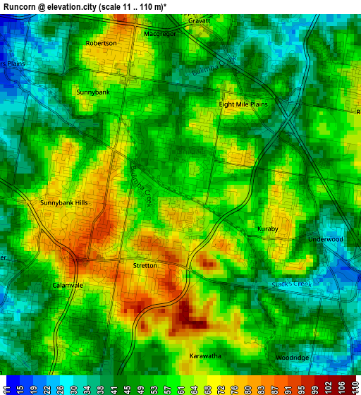
Below is the Elevation map of Runcorn, which displays elevation range with different colors. Scale of the first map is from 11 to 110 m (36 to 361 ft) with average elevation of 53.9 meters (=177 ft) [note 1]
These maps also provides idea of topography and contour of this city, they are displayed at different zoom levels. More info about maps, scale and edge coordinates you can find below images.
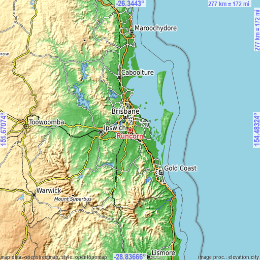
| \ | Map #1 | Map #2 | Topo.Map |
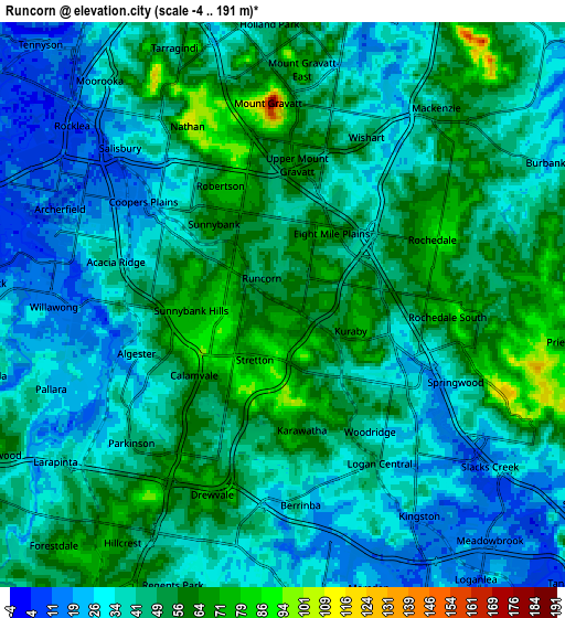
| Scale [m] | 11..110 m | -4..191 m | × |
| Scale [ft] | 36..361 ft | -13..627 ft | × |
| Average | 53.9 m = 177 ft | 42.9 m = 141 ft | × |
| Width | 8.66 km = 5.4 mi | 17.32 km = 10.8 mi | 277.1 km = 172.2 mi |
| Height | 8.66 km = 5.4 mi | 17.32 km = 10.8 mi | 277.1 km = 172.2 mi |
| ↑Max Latitude | -27.558608° | -27.519642° | -26.3443° |
| Latitude at center | -27.59756° | -27.59756° | -27.59756° |
| ↓Min Latitude | -27.636498° | -27.675423° | -28.83666° |
| ← Min Longitude | 153.033045° | 152.989099° | 151.67074° |
| Longitude center | 153.07699° | 153.07699° | 153.07699° |
| →Max Longitude | 153.120935° | 153.164881° | 154.48324° |
Nearby cities:
Cities around Runcorn sort by population:
• Sunnybank Hills elevation 85 m
2.7 km,  238°
238°
• Calamvale 61 m
4.1 km,  225°
225°
• Eight Mile Plains 35 m
2.8 km,  55°
55°
• Rochedale South 59 m
4.6 km,  86°
86°
• Upper Mount Gravatt 63 m
4.1 km,  10°
10°
• Sunnybank 44 m
2.5 km,  320°
320°
• Kuraby 52 m
1.9 km,  122°
122°
• Underwood 32 m
3.6 km,  110°
110°
• Macgregor 69 m
3.8 km,  344°
344°
• Robertson 74 m
4 km,  331°
331°
• Stretton 98 m
2.9 km,  201°
201°
• Nathan 91 m
4.5 km, 341°
Multilingual:
 En español:
Runcorn elevación 59 m.
 En France:
Runcorn élévation 59 m.


Sources and notes:
- [note 1] Map square and city borders are not equal. Map elevation data is calculated only from area inside that square.
- [src 1] Elevation data from geonames database provided with same terms of usage.
- [src 2] The elevation map of Runcorn is generated using elevation data from NASA's 3 arcsec (90m) resolution SRTM data.
- [src 3] Base (background) map © OpenStreetMap contributors tiles are generated by Geofabrik and OpenTopoMap.
Copyright & License:
This Runcorn Elevation Map is licensed under CC BY-SA. You may reuse any part from this page, if you give a proper credit by linking to this URL:
 More info on terms of use page.