Gilberton elevation
Gilberton (South Australia, Walkerville), Australia elevation is 42 meters and Gilberton elevation in feet is 138 ft above sea level [src 1]. Gilberton is a section of populated place (feature code) with elevation that is 71 meters (233 ft) smaller than average city elevation in Australia.
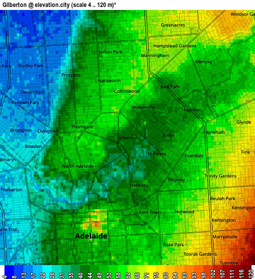
Below is the Elevation map of Gilberton, which displays elevation range with different colors. Scale of the first map is from 4 to 120 m (13 to 394 ft) with average elevation of 48.9 meters (=160 ft) [note 1]
These maps also provides idea of topography and contour of this city, they are displayed at different zoom levels. More info about maps, scale and edge coordinates you can find below images.
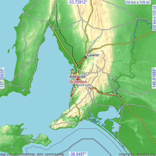
| \ | Map #1 | Topo.Map |
| Scale [m] | 4..120 m | × |
| Scale [ft] | 13..394 ft | × |
| Average | 48.9 m = 160 ft | × |
| Width | 8.01 km = 5 mi | 256.5 km = 159.4 mi |
| Height | 8.01 km = 5 mi | 256.5 km = 159.4 mi |
| ↑Max Latitude | -34.86446° | -33.73912° |
| Latitude at center | -34.90051° | -34.90051° |
| ↓Min Latitude | -34.936544° | -36.0457° |
| ← Min Longitude | 138.568655° | 137.20635° |
| Longitude center | 138.6126° | 138.6126° |
| →Max Longitude | 138.656545° | 140.01885° |
Nearby cities:
Cities around Gilberton sort by population:
• North Adelaide elevation 50 m
2.1 km,  248°
248°
• St Peters 42 m
1 km,  118°
118°
• Marden 57 m
2.4 km,  76°
76°
• Vale Park 47 m
2.1 km,  39°
39°
• Nailsworth 56 m
1.9 km,  341°
341°
• Maylands 60 m
2.5 km, 118°
• Evandale 57 m
2.2 km,  104°
104°
• Collinswood 61 m
1.5 km,  358°
358°
• Kent Town 51 m
2.4 km,  163°
163°
• Medindie 59 m
0.9 km,  305°
305°
• Royston Park 55 m
1.8 km, 79°
• Joslin 43 m
1.3 km,  85°
85°
Multilingual:
 En español:
Gilberton elevación 42 m.
 En France:
Gilberton élévation 42 m.
 Auf Deutsch:
Gilberton höhe über dem Meeresspiegel ist 42 m.

Sources and notes:
- [note 1] Map square and city borders are not equal. Map elevation data is calculated only from area inside that square.
- [src 1] Elevation data from geonames database provided with same terms of usage.
- [src 2] The elevation map of Gilberton is generated using elevation data from NASA's 3 arcsec (90m) resolution SRTM data.
- [src 3] Base (background) map © OpenStreetMap contributors tiles are generated by Geofabrik and OpenTopoMap.
Copyright & License:
This Gilberton Elevation Map is licensed under CC BY-SA. You may reuse any part from this page, if you give a proper credit by linking to this URL:
 More info on terms of use page.