Medindie elevation
Medindie (South Australia, Walkerville), Australia elevation is 59 meters and Medindie elevation in feet is 194 ft above sea level [src 1]. Medindie is a populated place (feature code) with elevation that is 54 meters (177 ft) smaller than average city elevation in Australia.
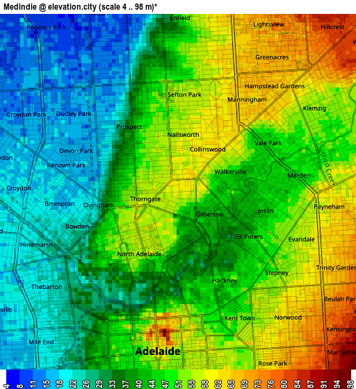
Below is the Elevation map of Medindie, which displays elevation range with different colors. Scale of the first map is from 4 to 98 m (13 to 322 ft) with average elevation of 43.3 meters (=142 ft) [note 1]
These maps also provides idea of topography and contour of this city, they are displayed at different zoom levels. More info about maps, scale and edge coordinates you can find below images.
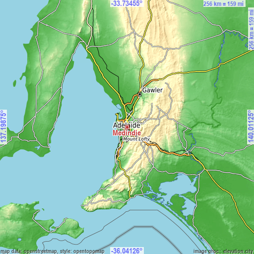
| \ | Map #1 | Topo.Map |
| Scale [m] | 4..98 m | × |
| Scale [ft] | 13..322 ft | × |
| Average | 43.3 m = 142 ft | × |
| Width | 8.02 km = 5 mi | 256.5 km = 159.4 mi |
| Height | 8.02 km = 5 mi | 256.5 km = 159.4 mi |
| ↑Max Latitude | -34.859949° | -33.73455° |
| Latitude at center | -34.896° | -34.896° |
| ↓Min Latitude | -34.932036° | -36.04126° |
| ← Min Longitude | 138.561055° | 137.19875° |
| Longitude center | 138.605° | 138.605° |
| →Max Longitude | 138.648945° | 140.01125° |
Nearby cities:
Cities around Medindie sort by population:
• Prospect elevation 43 m
1.8 km,  324°
324°
• North Adelaide 50 m
1.8 km,  224°
224°
• Broadview 60 m
2.4 km,  22°
22°
• Brompton 18 m
2.5 km,  274°
274°
• St Peters 42 m
1.9 km,  121°
121°
• Vale Park 47 m
2.3 km,  61°
61°
• Nailsworth 56 m
1.3 km,  4°
4°
• Gilberton 42 m
0.9 km,  125°
125°
• Collinswood 61 m
1.2 km,  34°
34°
• Sefton Park 50 m
2.4 km,  356°
356°
• Royston Park 55 m
2.4 km,  94°
94°
• Joslin 43 m
2 km,  101°
101°
Multilingual:
 En español:
Medindie elevación 59 m.
 En France:
Medindie élévation 59 m.


Sources and notes:
- [note 1] Map square and city borders are not equal. Map elevation data is calculated only from area inside that square.
- [src 1] Elevation data from geonames database provided with same terms of usage.
- [src 2] The elevation map of Medindie is generated using elevation data from NASA's 3 arcsec (90m) resolution SRTM data.
- [src 3] Base (background) map © OpenStreetMap contributors tiles are generated by Geofabrik and OpenTopoMap.
Copyright & License:
This Medindie Elevation Map is licensed under CC BY-SA. You may reuse any part from this page, if you give a proper credit by linking to this URL:
 More info on terms of use page.