Onkaparinga Hills elevation
Onkaparinga Hills (South Australia, Onkaparinga), Australia elevation is 217 meters and Onkaparinga Hills elevation in feet is 712 ft above sea level [src 1]. Onkaparinga Hills is a section of populated place (feature code) with elevation that is 104 meters (341 ft) bigger than average city elevation in Australia.
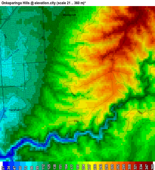
Below is the Elevation map of Onkaparinga Hills, which displays elevation range with different colors. Scale of the first map is from 21 to 360 m (69 to 1181 ft) with average elevation of 175.9 meters (=577 ft) [note 1]
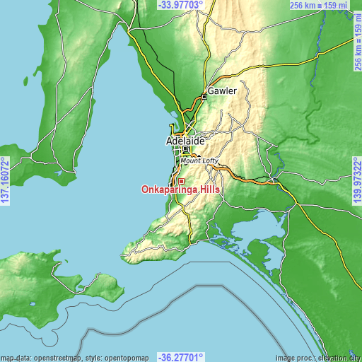
These maps also provides idea of topography and contour of this city, they are displayed at different zoom levels. More info about maps, scale and edge coordinates you can find below images.
| \ | Map #1 | Topo.Map |
| Scale [m] | 21..360 m | × |
| Scale [ft] | 69..1181 ft | × |
| Average | 175.9 m = 577 ft | × |
| Width | 7.99 km = 5 mi | 255.7 km = 158.9 mi |
| Height | 7.99 km = 5 mi | 255.7 km = 158.9 mi |
| ↑Max Latitude | -35.099194° | -33.97703° |
| Latitude at center | -35.13514° | -35.13514° |
| ↓Min Latitude | -35.17107° | -36.27701° |
| ← Min Longitude | 138.523025° | 137.16072° |
| Longitude center | 138.56697° | 138.56697° |
| →Max Longitude | 138.610915° | 139.97322° |
Nearby cities:
Cities around Onkaparinga Hills sort by population:
• Morphett Vale elevation 92 m
4.6 km,  272°
272°
• Happy Valley 120 m
6.5 km,  332°
332°
• Woodcroft 142 m
3.7 km,  354°
354°
• Aberfoyle Park 177 m
6.9 km,  19°
19°
• Christie Downs 63 m
6.4 km,  275°
275°
• Reynella 120 m
5.7 km,  324°
324°
• Huntfield Heights 70 m
5.3 km,  245°
245°
• Hackham 75 m
4.4 km,  239°
239°
• Noarlunga Downs 45 m
6 km, 253°
• Hackham West 81 m
4.9 km,  259°
259°
• Old Reynella 105 m
4.6 km, 319°
• Reynella East 120 m
4.9 km, 349°
Multilingual:
 En español:
Onkaparinga Hills elevación 217 m.
 En France:
Onkaparinga Hills élévation 217 m.
 Auf Deutsch:
Onkaparinga Hills höhe über dem Meeresspiegel ist 217 m.

Sources and notes:
- [note 1] Map square and city borders are not equal. Map elevation data is calculated only from area inside that square.
- [src 1] Elevation data from geonames database provided with same terms of usage.
- [src 2] The elevation map of Onkaparinga Hills is generated using elevation data from NASA's 3 arcsec (90m) resolution SRTM data.
- [src 3] Base (background) map © OpenStreetMap contributors tiles are generated by Geofabrik and OpenTopoMap.
Copyright & License:
This Onkaparinga Hills Elevation Map is licensed under CC BY-SA. You may reuse any part from this page, if you give a proper credit by linking to this URL:
 More info on terms of use page.