Noarlunga Downs elevation
Noarlunga Downs (South Australia, Onkaparinga), Australia elevation is 45 meters and Noarlunga Downs elevation in feet is 148 ft above sea level [src 1]. Noarlunga Downs is a section of populated place (feature code) with elevation that is 68 meters (223 ft) smaller than average city elevation in Australia.
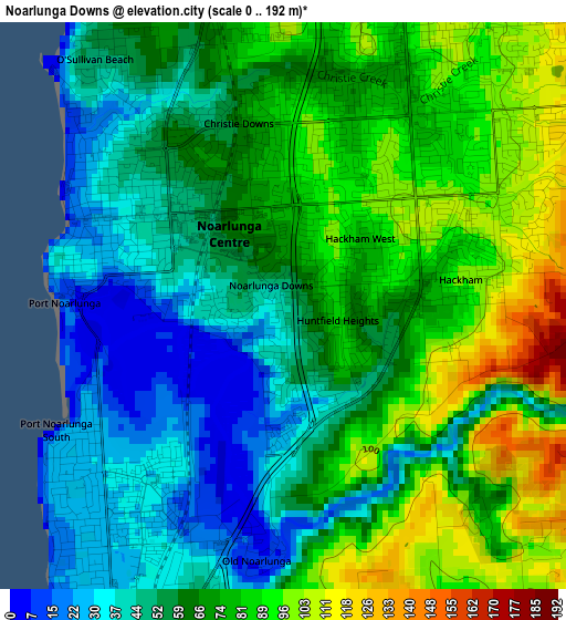
Below is the Elevation map of Noarlunga Downs, which displays elevation range with different colors. Scale of the first map is from 0 to 192 m (0 to 630 ft) with average elevation of 65.8 meters (=216 ft) [note 1]
These maps also provides idea of topography and contour of this city, they are displayed at different zoom levels. More info about maps, scale and edge coordinates you can find below images.
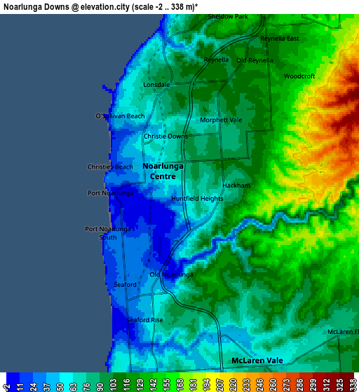
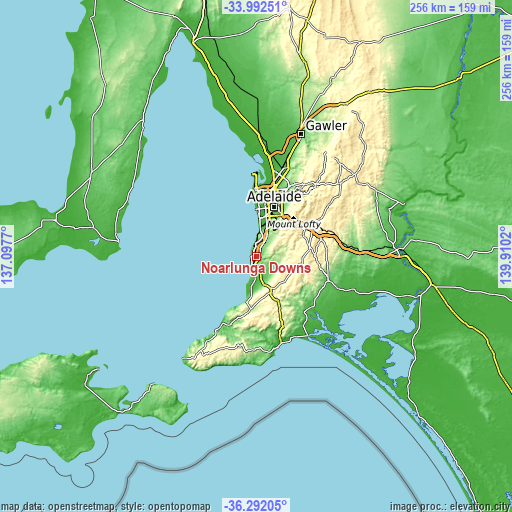
| \ | Map #1 | Map #2 | Topo.Map |
| Scale [m] | 0..192 m | -2..338 m | × |
| Scale [ft] | 0..630 ft | -7..1109 ft | × |
| Average | 65.8 m = 216 ft | 102 m = 335 ft | × |
| Width | 7.99 km = 5 mi | 15.98 km = 9.9 mi | 255.7 km = 158.9 mi |
| Height | 7.99 km = 5 mi | 15.98 km = 9.9 mi | 255.7 km = 158.9 mi |
| ↑Max Latitude | -35.11446° | -35.078505° | -33.99251° |
| Latitude at center | -35.1504° | -35.1504° | -35.1504° |
| ↓Min Latitude | -35.186324° | -35.222231° | -36.29205° |
| ← Min Longitude | 138.460005° | 138.416059° | 137.0977° |
| Longitude center | 138.50395° | 138.50395° | 138.50395° |
| →Max Longitude | 138.547895° | 138.591841° | 139.9102° |
Nearby cities:
Cities around Noarlunga Downs sort by population:
• Morphett Vale elevation 92 m
2.2 km,  31°
31°
• Seaford Rise 37 m
5.1 km,  203°
203°
• Christies Beach 17 m
3.2 km,  294°
294°
• Christie Downs 63 m
2.4 km,  343°
343°
• Huntfield Heights 70 m
1 km,  116°
116°
• Hackham 75 m
2 km,  105°
105°
• Seaford Meadows 28 m
2.9 km,  210°
210°
• Hackham West 81 m
1.2 km,  49°
49°
• Port Noarlunga 8 m
3 km,  275°
275°
• Port Noarlunga South 24 m
4.2 km,  230°
230°
• O'Sullivan Beach 51 m
4.5 km,  321°
321°
• Old Noarlunga 9 m
3.5 km,  183°
183°
Multilingual:
 En español:
Noarlunga Downs elevación 45 m.
 En France:
Noarlunga Downs élévation 45 m.
 Auf Deutsch:
Noarlunga Downs höhe über dem Meeresspiegel ist 45 m.

Sources and notes:
- [note 1] Map square and city borders are not equal. Map elevation data is calculated only from area inside that square.
- [src 1] Elevation data from geonames database provided with same terms of usage.
- [src 2] The elevation map of Noarlunga Downs is generated using elevation data from NASA's 3 arcsec (90m) resolution SRTM data.
- [src 3] Base (background) map © OpenStreetMap contributors tiles are generated by Geofabrik and OpenTopoMap.
Copyright & License:
This Noarlunga Downs Elevation Map is licensed under CC BY-SA. You may reuse any part from this page, if you give a proper credit by linking to this URL:
 More info on terms of use page.