Magill elevation
Magill (South Australia, Campbelltown), Australia elevation is 120 meters and Magill elevation in feet is 394 ft above sea level [src 1]. Magill is a section of populated place (feature code) with elevation that is 7 meters (23 ft) bigger than average city elevation in Australia.
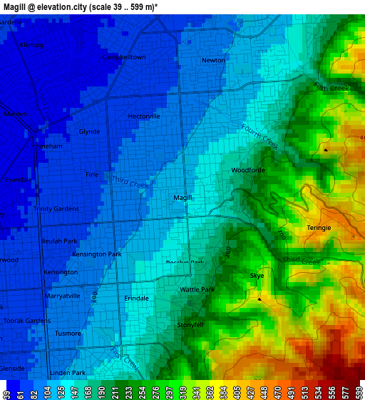
Below is the Elevation map of Magill, which displays elevation range with different colors. Scale of the first map is from 39 to 599 m (128 to 1965 ft) with average elevation of 174.6 meters (=573 ft) [note 1]
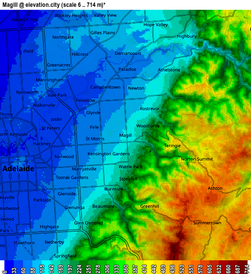
These maps also provides idea of topography and contour of this city, they are displayed at different zoom levels. More info about maps, scale and edge coordinates you can find below images.
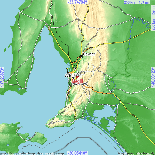
| \ | Map #1 | Map #2 | Topo.Map |
| Scale [m] | 39..599 m | 6..714 m | × |
| Scale [ft] | 128..1965 ft | 20..2343 ft | × |
| Average | 174.6 m = 573 ft | 218.6 m = 717 ft | × |
| Width | 8.01 km = 5 mi | 16.03 km = 10 mi | 256.4 km = 159.3 mi |
| Height | 8.01 km = 5 mi | 16.03 km = 10 mi | 256.4 km = 159.3 mi |
| ↑Max Latitude | -34.873064° | -34.837003° | -33.74784° |
| Latitude at center | -34.90911° | -34.90911° | -34.90911° |
| ↓Min Latitude | -34.94514° | -34.981154° | -36.05418° |
| ← Min Longitude | 138.631035° | 138.587089° | 137.26873° |
| Longitude center | 138.67498° | 138.67498° | 138.67498° |
| →Max Longitude | 138.718925° | 138.762871° | 140.08123° |
Nearby cities:
Cities around Magill sort by population:
• Rostrevor elevation 137 m
2.3 km,  42°
42°
• Tranmere 97 m
1.2 km,  288°
288°
• Hectorville 71 m
2.4 km,  323°
323°
• Kensington Park 92 m
2.3 km,  236°
236°
• Kensington Gardens 123 m
2.2 km,  213°
213°
• Glynde 70 m
2.5 km,  305°
305°
• Wattle Park 159 m
1.8 km,  179°
179°
• Leabrook 118 m
2.7 km, 213°
• St Morris 81 m
2 km,  263°
263°
• Rosslyn Park 158 m
1.4 km, 177°
• Firle 77 m
2 km,  284°
284°
• Erindale 133 m
2.3 km, 207°
Multilingual:
 En español:
Magill elevación 120 m.
 En France:
Magill élévation 120 m.


Sources and notes:
- [note 1] Map square and city borders are not equal. Map elevation data is calculated only from area inside that square.
- [src 1] Elevation data from geonames database provided with same terms of usage.
- [src 2] The elevation map of Magill is generated using elevation data from NASA's 3 arcsec (90m) resolution SRTM data.
- [src 3] Base (background) map © OpenStreetMap contributors tiles are generated by Geofabrik and OpenTopoMap.
Copyright & License:
This Magill Elevation Map is licensed under CC BY-SA. You may reuse any part from this page, if you give a proper credit by linking to this URL:
 More info on terms of use page.