Maraylya elevation
Maraylya (New South Wales, The Hills Shire), Australia elevation is 34 meters and Maraylya elevation in feet is 112 ft above sea level [src 1]. Maraylya is a section of populated place (feature code) with elevation that is 79 meters (259 ft) smaller than average city elevation in Australia.
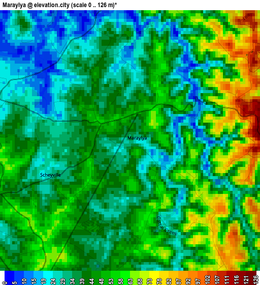
Below is the Elevation map of Maraylya, which displays elevation range with different colors. Scale of the first map is from 0 to 126 m (0 to 413 ft) with average elevation of 43.6 meters (=143 ft) [note 1]
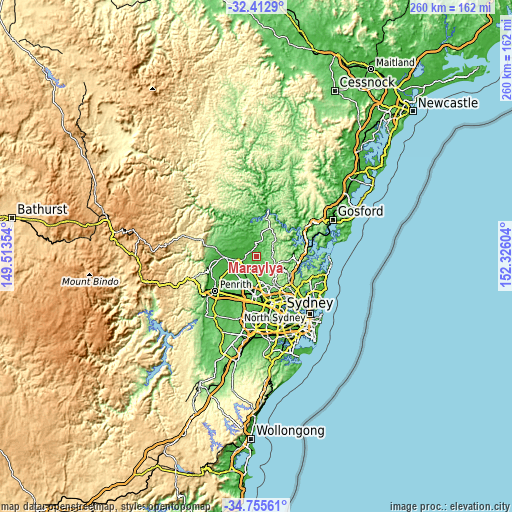
These maps also provides idea of topography and contour of this city, they are displayed at different zoom levels. More info about maps, scale and edge coordinates you can find below images.
| \ | Map #1 | Topo.Map |
| Scale [m] | 0..126 m | × |
| Scale [ft] | 0..413 ft | × |
| Average | 43.6 m = 143 ft | × |
| Width | 8.14 km = 5.1 mi | 260.5 km = 161.9 mi |
| Height | 8.14 km = 5.1 mi | 260.5 km = 161.9 mi |
| ↑Max Latitude | -33.555596° | -32.4129° |
| Latitude at center | -33.59221° | -33.59221° |
| ↓Min Latitude | -33.628809° | -34.75561° |
| ← Min Longitude | 150.875845° | 149.51354° |
| Longitude center | 150.91979° | 150.91979° |
| →Max Longitude | 150.963735° | 152.32604° |
Nearby cities:
Cities around Maraylya sort by population:
• Rouse Hill elevation 53 m
10 km,  182°
182°
• South Windsor 26 m
11.1 km,  254°
254°
• Kenthurst 136 m
10.6 km,  131°
131°
• Glenorie 163 m
8.3 km,  97°
97°
• Pitt Town 11 m
5.7 km,  275°
275°
• Wilberforce 18 m
8.3 km,  293°
293°
• McGraths Hill 15 m
8.4 km, 251°
• Windsor 16 m
10.1 km,  256°
256°
• Oakville 45 m
4.5 km,  234°
234°
• Annangrove 80 m
7.7 km,  160°
160°
• Arcadia 156 m
10.9 km, 104°
• Vineyard 37 m
8.9 km,  224°
224°
Multilingual:
 En español:
Maraylya elevación 34 m.
 En France:
Maraylya élévation 34 m.


Sources and notes:
- [note 1] Map square and city borders are not equal. Map elevation data is calculated only from area inside that square.
- [src 1] Elevation data from geonames database provided with same terms of usage.
- [src 2] The elevation map of Maraylya is generated using elevation data from NASA's 3 arcsec (90m) resolution SRTM data.
- [src 3] Base (background) map © OpenStreetMap contributors tiles are generated by Geofabrik and OpenTopoMap.
Copyright & License:
This Maraylya Elevation Map is licensed under CC BY-SA. You may reuse any part from this page, if you give a proper credit by linking to this URL:
 More info on terms of use page.