Kenthurst elevation
Kenthurst (New South Wales, The Hills Shire), Australia elevation is 136 meters and Kenthurst elevation in feet is 446 ft above sea level [src 1]. Kenthurst is a section of populated place (feature code) with elevation that is 23 meters (75 ft) bigger than average city elevation in Australia.
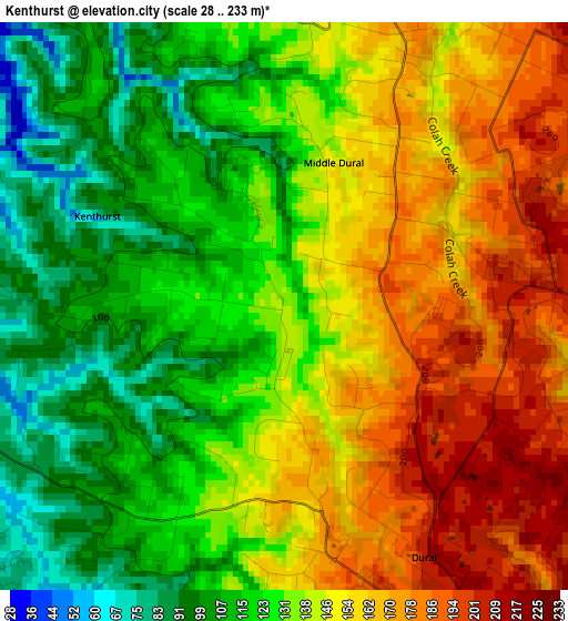
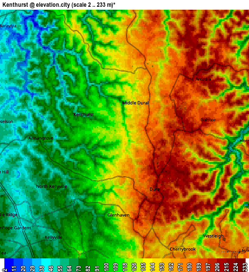
Below is the Elevation map of Kenthurst, which displays elevation range with different colors. Scale of the first map is from 28 to 233 m (92 to 764 ft) with average elevation of 139 meters (=456 ft) [note 1]
These maps also provides idea of topography and contour of this city, they are displayed at different zoom levels. More info about maps, scale and edge coordinates you can find below images.
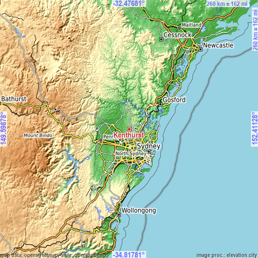
| \ | Map #1 | Map #2 | Topo.Map |
| Scale [m] | 28..233 m | 2..233 m | × |
| Scale [ft] | 92..764 ft | 7..764 ft | × |
| Average | 139 m = 456 ft | 126.5 m = 415 ft | × |
| Width | 8.13 km = 5.1 mi | 16.27 km = 10.1 mi | 260.3 km = 161.7 mi |
| Height | 8.13 km = 5.1 mi | 16.27 km = 10.1 mi | 260.3 km = 161.7 mi |
| ↑Max Latitude | -33.618683° | -33.58208° | -32.47681° |
| Latitude at center | -33.65527° | -33.65527° | -33.65527° |
| ↓Min Latitude | -33.691842° | -33.728398° | -34.81781° |
| ← Min Longitude | 150.961085° | 150.917139° | 149.59878° |
| Longitude center | 151.00503° | 151.00503° | 151.00503° |
| →Max Longitude | 151.048975° | 151.092921° | 152.41128° |
Nearby cities:
Cities around Kenthurst sort by population:
• Castle Hill elevation 126 m
8.7 km,  183°
183°
• Kellyville 67 m
7.9 km,  219°
219°
• Cherrybrook 157 m
8.3 km,  152°
152°
• Beaumont Hills 58 m
7.7 km,  229°
229°
• Dural 184 m
3.3 km,  160°
160°
• Glenhaven 137 m
5 km,  185°
185°
• Hornsby Heights 185 m
8.4 km,  102°
102°
• Westleigh 156 m
8.8 km,  135°
135°
• Glenorie 163 m
6 km,  3°
3°
• Galston 208 m
3.9 km,  86°
86°
• Annangrove 80 m
5.3 km,  267°
267°
• Arcadia 156 m
5 km,  31°
31°
Multilingual:
 En español:
Kenthurst elevación 136 m.
 En France:
Kenthurst élévation 136 m.
 Auf Deutsch:
Kenthurst höhe über dem Meeresspiegel ist 136 m.

Sources and notes:
- [note 1] Map square and city borders are not equal. Map elevation data is calculated only from area inside that square.
- [src 1] Elevation data from geonames database provided with same terms of usage.
- [src 2] The elevation map of Kenthurst is generated using elevation data from NASA's 3 arcsec (90m) resolution SRTM data.
- [src 3] Base (background) map © OpenStreetMap contributors tiles are generated by Geofabrik and OpenTopoMap.
Copyright & License:
This Kenthurst Elevation Map is licensed under CC BY-SA. You may reuse any part from this page, if you give a proper credit by linking to this URL:
 More info on terms of use page.