Kew East elevation
Kew East (Victoria, Boroondara), Australia elevation is 46 meters and Kew East elevation in feet is 151 ft above sea level [src 1]. Kew East is a section of populated place (feature code) with elevation that is 67 meters (220 ft) smaller than average city elevation in Australia.
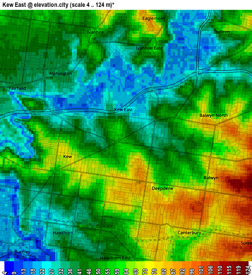
Below is the Elevation map of Kew East, which displays elevation range with different colors. Scale of the first map is from 4 to 124 m (13 to 407 ft) with average elevation of 49.7 meters (=163 ft) [note 1]
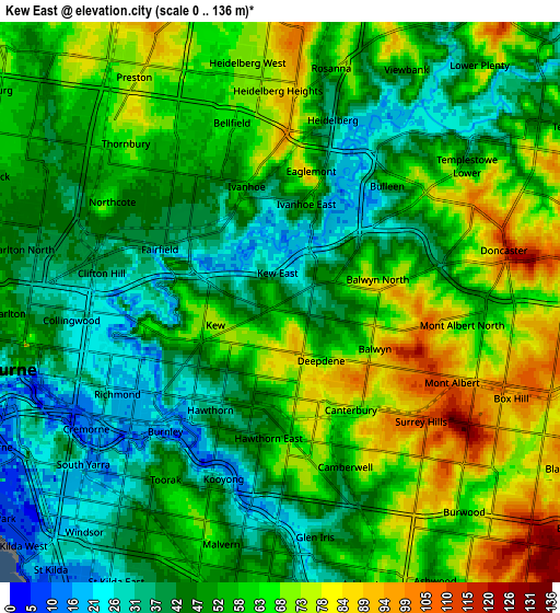
These maps also provides idea of topography and contour of this city, they are displayed at different zoom levels. More info about maps, scale and edge coordinates you can find below images.
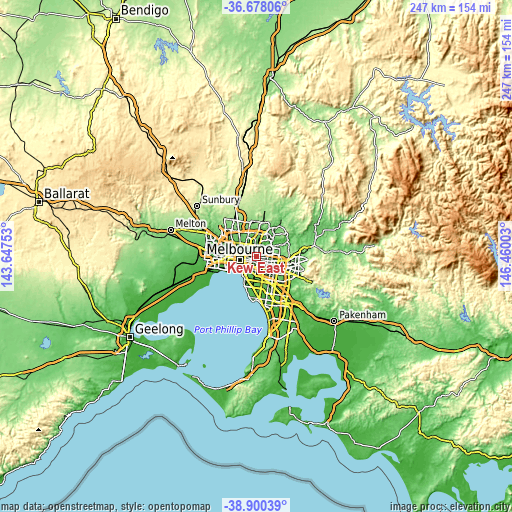
| \ | Map #1 | Map #2 | Topo.Map |
| Scale [m] | 4..124 m | 0..136 m | × |
| Scale [ft] | 13..407 ft | 0..446 ft | × |
| Average | 49.7 m = 163 ft | 54.8 m = 180 ft | × |
| Width | 7.72 km = 4.8 mi | 15.44 km = 9.6 mi | 247.1 km = 153.5 mi |
| Height | 7.72 km = 4.8 mi | 15.44 km = 9.6 mi | 247.1 km = 153.5 mi |
| ↑Max Latitude | -37.762847° | -37.728098° | -36.67806° |
| Latitude at center | -37.79758° | -37.79758° | -37.79758° |
| ↓Min Latitude | -37.832297° | -37.866997° | -38.90039° |
| ← Min Longitude | 145.009835° | 144.965889° | 143.64753° |
| Longitude center | 145.05378° | 145.05378° | 145.05378° |
| →Max Longitude | 145.097725° | 145.141671° | 146.46003° |
Nearby cities:
Cities around Kew East sort by population:
• Kew elevation 64 m
2.2 km,  244°
244°
• Hawthorn 30 m
2.9 km,  212°
212°
• Glenferrie 53 m
4 km,  184°
184°
• Balwyn North 59 m
3.6 km,  78°
78°
• Hawthorn East 49 m
3.1 km,  192°
192°
• Balwyn 136 m
2.6 km,  120°
120°
• Ivanhoe 56 m
3.3 km,  343°
343°
• Canterbury 83 m
4.1 km,  137°
137°
• Fairfield 39 m
3.7 km,  301°
301°
• Alphington 36 m
2.4 km,  311°
311°
• Eaglemont 59 m
3.9 km,  13°
13°
• Ivanhoe East 19 m
2.8 km, 14°
Multilingual:
 En español:
Kew East elevación 46 m.
 En France:
Kew East élévation 46 m.


Sources and notes:
- [note 1] Map square and city borders are not equal. Map elevation data is calculated only from area inside that square.
- [src 1] Elevation data from geonames database provided with same terms of usage.
- [src 2] The elevation map of Kew East is generated using elevation data from NASA's 3 arcsec (90m) resolution SRTM data.
- [src 3] Base (background) map © OpenStreetMap contributors tiles are generated by Geofabrik and OpenTopoMap.
Copyright & License:
This Kew East Elevation Map is licensed under CC BY-SA. You may reuse any part from this page, if you give a proper credit by linking to this URL:
 More info on terms of use page.