Hawthorn East elevation
Hawthorn East (Victoria, Boroondara), Australia elevation is 49 meters and Hawthorn East elevation in feet is 161 ft above sea level [src 1]. Hawthorn East is a section of populated place (feature code) with elevation that is 64 meters (210 ft) smaller than average city elevation in Australia.
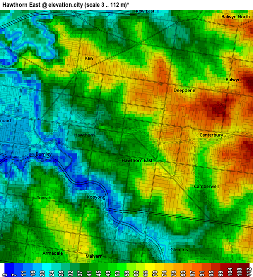
Below is the Elevation map of Hawthorn East, which displays elevation range with different colors. Scale of the first map is from 3 to 112 m (10 to 367 ft) with average elevation of 49.1 meters (=161 ft) [note 1]
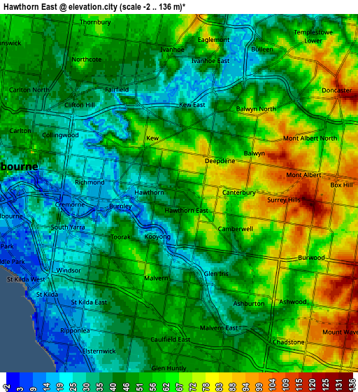
These maps also provides idea of topography and contour of this city, they are displayed at different zoom levels. More info about maps, scale and edge coordinates you can find below images.
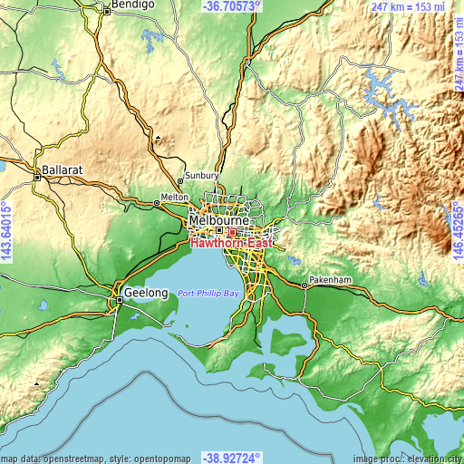
| \ | Map #1 | Map #2 | Topo.Map |
| Scale [m] | 3..112 m | -2..136 m | × |
| Scale [ft] | 10..367 ft | -7..446 ft | × |
| Average | 49.1 m = 161 ft | 51 m = 167 ft | × |
| Width | 7.72 km = 4.8 mi | 15.44 km = 9.6 mi | 247 km = 153.5 mi |
| Height | 7.72 km = 4.8 mi | 15.44 km = 9.6 mi | 247 km = 153.5 mi |
| ↑Max Latitude | -37.79012° | -37.755383° | -36.70573° |
| Latitude at center | -37.82484° | -37.82484° | -37.82484° |
| ↓Min Latitude | -37.859544° | -37.894231° | -38.92724° |
| ← Min Longitude | 145.002455° | 144.958509° | 143.64015° |
| Longitude center | 145.0464° | 145.0464° | 145.0464° |
| →Max Longitude | 145.090345° | 145.134291° | 146.45265° |
Nearby cities:
Cities around Hawthorn East sort by population:
• Richmond elevation 20 m
4 km,  280°
280°
• Kew 64 m
2.5 km,  326°
326°
• Hawthorn 30 m
1.1 km,  300°
300°
• Camberwell 47 m
2.8 km,  133°
133°
• Hawthorn South 48 m
1.2 km,  223°
223°
• Glenferrie 53 m
1 km,  161°
161°
• Balwyn 136 m
3.3 km,  58°
58°
• Toorak 55 m
3.4 km,  236°
236°
• Malvern 60 m
4.5 km,  200°
200°
• Armadale 52 m
4.1 km,  213°
213°
• Canterbury 83 m
3.4 km,  89°
89°
• Kew East 46 m
3.1 km,  12°
12°
Multilingual:
 En español:
Hawthorn East elevación 49 m.
 En France:
Hawthorn East élévation 49 m.
 Auf Deutsch:
Hawthorn East höhe über dem Meeresspiegel ist 49 m.

Sources and notes:
- [note 1] Map square and city borders are not equal. Map elevation data is calculated only from area inside that square.
- [src 1] Elevation data from geonames database provided with same terms of usage.
- [src 2] The elevation map of Hawthorn East is generated using elevation data from NASA's 3 arcsec (90m) resolution SRTM data.
- [src 3] Base (background) map © OpenStreetMap contributors tiles are generated by Geofabrik and OpenTopoMap.
Copyright & License:
This Hawthorn East Elevation Map is licensed under CC BY-SA. You may reuse any part from this page, if you give a proper credit by linking to this URL:
 More info on terms of use page.