Connells Point elevation
Connells Point (New South Wales, Georges River), Australia elevation is 18 meters and Connells Point elevation in feet is 59 ft above sea level [src 1]. Connells Point is a section of populated place (feature code) with elevation that is 95 meters (312 ft) smaller than average city elevation in Australia.
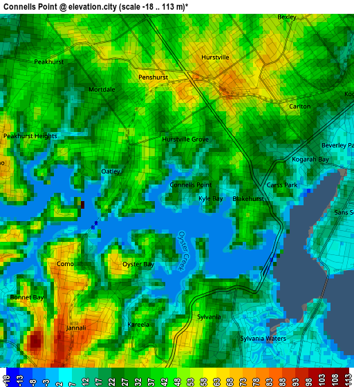
Below is the Elevation map of Connells Point, which displays elevation range with different colors. Scale of the first map is from -18 to 113 m (-59 to 371 ft) with average elevation of 31.3 meters (=103 ft) [note 1]
These maps also provides idea of topography and contour of this city, they are displayed at different zoom levels. More info about maps, scale and edge coordinates you can find below images.
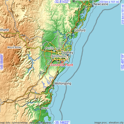
| \ | Map #1 | Topo.Map |
| Scale [m] | -18..113 m | × |
| Scale [ft] | -59..371 ft | × |
| Average | 31.3 m = 103 ft | × |
| Width | 8.1 km = 5 mi | 259.3 km = 161.1 mi |
| Height | 8.1 km = 5 mi | 259.3 km = 161.1 mi |
| ↑Max Latitude | -33.951825° | -32.81432° |
| Latitude at center | -33.98827° | -33.98827° |
| ↓Min Latitude | -34.0247° | -35.14622° |
| ← Min Longitude | 151.046995° | 149.68469° |
| Longitude center | 151.09094° | 151.09094° |
| →Max Longitude | 151.134885° | 152.49719° |
Nearby cities:
Cities around Connells Point sort by population:
• Hurstville elevation 80 m
2.5 km,  23°
23°
• Penshurst 63 m
2.5 km,  343°
343°
• Sylvania 35 m
2.7 km,  167°
167°
• Mortdale 63 m
2.7 km,  321°
321°
• Oatley 42 m
2 km,  297°
297°
• Blakehurst 46 m
1.7 km,  102°
102°
• Allawah 39 m
2.8 km,  51°
51°
• Oyster Bay 69 m
2.2 km,  218°
218°
• South Hurstville 38 m
1.8 km, 48°
• Hurstville Grove 32 m
0.9 km,  356°
356°
• Carss Park 17 m
2.4 km,  85°
85°
• Kyle Bay 29 m
0.8 km, 86°
Multilingual:
 En español:
Connells Point elevación 18 m.
 En France:
Connells Point élévation 18 m.
 Auf Deutsch:
Connells Point höhe über dem Meeresspiegel ist 18 m.

Sources and notes:
- [note 1] Map square and city borders are not equal. Map elevation data is calculated only from area inside that square.
- [src 1] Elevation data from geonames database provided with same terms of usage.
- [src 2] The elevation map of Connells Point is generated using elevation data from NASA's 3 arcsec (90m) resolution SRTM data.
- [src 3] Base (background) map © OpenStreetMap contributors tiles are generated by Geofabrik and OpenTopoMap.
Copyright & License:
This Connells Point Elevation Map is licensed under CC BY-SA. You may reuse any part from this page, if you give a proper credit by linking to this URL:
 More info on terms of use page.