Bayswater elevation
Bayswater (Victoria, Knox), Australia elevation is 108 meters and Bayswater elevation in feet is 354 ft above sea level [src 1]. Bayswater is a section of populated place (feature code) with elevation that is 5 meters (16 ft) smaller than average city elevation in Australia.
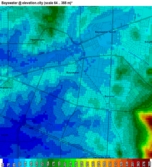
Below is the Elevation map of Bayswater, which displays elevation range with different colors. Scale of the first map is from 64 to 388 m (210 to 1273 ft) with average elevation of 115.8 meters (=380 ft) [note 1]
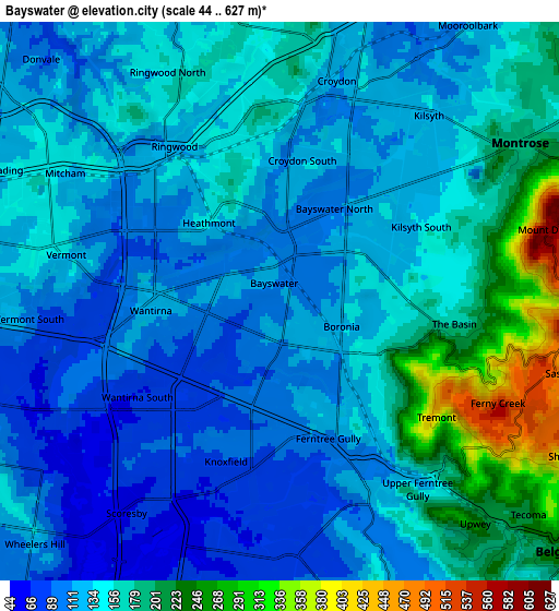
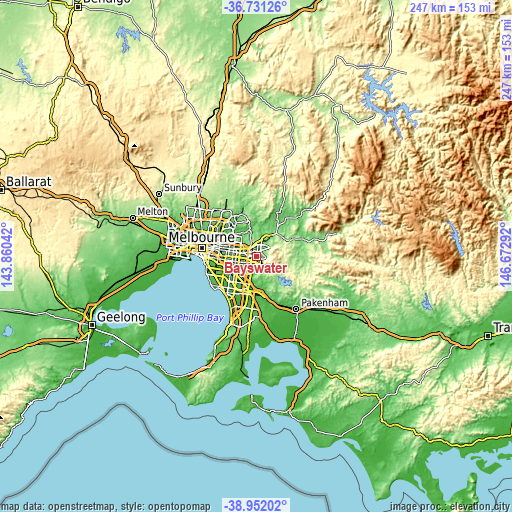
These maps also provides idea of topography and contour of this city, they are displayed at different zoom levels. More info about maps, scale and edge coordinates you can find below images.
| \ | Map #1 | Map #2 | Topo.Map |
| Scale [m] | 64..388 m | 44..627 m | × |
| Scale [ft] | 210..1273 ft | 144..2057 ft | × |
| Average | 115.8 m = 380 ft | 146.7 m = 481 ft | × |
| Width | 7.72 km = 4.8 mi | 15.43 km = 9.6 mi | 246.9 km = 153.4 mi |
| Height | 7.72 km = 4.8 mi | 15.43 km = 9.6 mi | 246.9 km = 153.4 mi |
| ↑Max Latitude | -37.815292° | -37.780567° | -36.73126° |
| Latitude at center | -37.85° | -37.85° | -37.85° |
| ↓Min Latitude | -37.884692° | -37.919368° | -38.95202° |
| ← Min Longitude | 145.222725° | 145.178779° | 143.86042° |
| Longitude center | 145.26667° | 145.26667° | 145.26667° |
| →Max Longitude | 145.310615° | 145.354561° | 146.67292° |
Nearby cities:
Cities around Bayswater sort by population:
• Croydon elevation 109 m
5.7 km,  14°
14°
• Ferntree Gully 125 m
4.6 km,  146°
146°
• Boronia 109 m
2.4 km,  141°
141°
• Ringwood 137 m
4.7 km,  321°
321°
• Wantirna 91 m
4.4 km,  270°
270°
• Ringwood East 154 m
4 km,  338°
338°
• Heathmont 114 m
2.4 km, 321°
• Bayswater North 129 m
3.8 km,  46°
46°
• Knoxfield 90 m
4.7 km,  198°
198°
• Croydon South 108 m
4.2 km,  1°
1°
• The Basin 171 m
4.4 km,  90°
90°
• Kilsyth South 128 m
5.4 km, 52°
Multilingual:
 En español:
Bayswater elevación 108 m.
 En France:
Bayswater élévation 108 m.
 Auf Deutsch:
Bayswater höhe über dem Meeresspiegel ist 108 m.

Sources and notes:
- [note 1] Map square and city borders are not equal. Map elevation data is calculated only from area inside that square.
- [src 1] Elevation data from geonames database provided with same terms of usage.
- [src 2] The elevation map of Bayswater is generated using elevation data from NASA's 3 arcsec (90m) resolution SRTM data.
- [src 3] Base (background) map © OpenStreetMap contributors tiles are generated by Geofabrik and OpenTopoMap.
Copyright & License:
This Bayswater Elevation Map is licensed under CC BY-SA. You may reuse any part from this page, if you give a proper credit by linking to this URL:
 More info on terms of use page.