Heathmont elevation
Heathmont (Victoria, Maroondah), Australia elevation is 114 meters and Heathmont elevation in feet is 374 ft above sea level [src 1]. Heathmont is a section of populated place (feature code) with elevation that is 1 meters (3 ft) bigger than average city elevation in Australia.
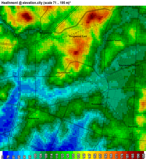
Below is the Elevation map of Heathmont, which displays elevation range with different colors. Scale of the first map is from 71 to 195 m (233 to 640 ft) with average elevation of 115.1 meters (=378 ft) [note 1]
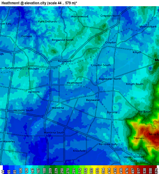
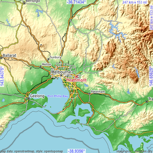
These maps also provides idea of topography and contour of this city, they are displayed at different zoom levels. More info about maps, scale and edge coordinates you can find below images.
| \ | Map #1 | Map #2 | Topo.Map |
| Scale [m] | 71..195 m | 44..579 m | × |
| Scale [ft] | 233..640 ft | 144..1900 ft | × |
| Average | 115.1 m = 378 ft | 128.4 m = 421 ft | × |
| Width | 7.72 km = 4.8 mi | 15.44 km = 9.6 mi | 247 km = 153.5 mi |
| Height | 7.72 km = 4.8 mi | 15.44 km = 9.6 mi | 247 km = 153.5 mi |
| ↑Max Latitude | -37.798614° | -37.763881° | -36.71434° |
| Latitude at center | -37.83333° | -37.83333° | -37.83333° |
| ↓Min Latitude | -37.86803° | -37.902713° | -38.9356° |
| ← Min Longitude | 145.206055° | 145.162109° | 143.84375° |
| Longitude center | 145.25° | 145.25° | 145.25° |
| →Max Longitude | 145.293945° | 145.337891° | 146.65625° |
Nearby cities:
Cities around Heathmont sort by population:
• Croydon elevation 109 m
4.7 km,  38°
38°
• Boronia 109 m
4.7 km,  141°
141°
• Ringwood 137 m
2.4 km,  321°
321°
• Mitcham 142 m
4.8 km,  292°
292°
• Wantirna 91 m
3.5 km,  237°
237°
• Bayswater 108 m
2.4 km, 141°
• Forest Hill 123 m
5.9 km,  270°
270°
• Ringwood East 154 m
1.9 km,  0°
0°
• Vermont 148 m
4.9 km, 266°
• Ringwood North 164 m
4 km,  338°
338°
• Bayswater North 129 m
4.3 km,  79°
79°
• Croydon South 108 m
2.8 km,  34°
34°
Multilingual:
 En español:
Heathmont elevación 114 m.
 En France:
Heathmont élévation 114 m.
 Auf Deutsch:
Heathmont höhe über dem Meeresspiegel ist 114 m.

Sources and notes:
- [note 1] Map square and city borders are not equal. Map elevation data is calculated only from area inside that square.
- [src 1] Elevation data from geonames database provided with same terms of usage.
- [src 2] The elevation map of Heathmont is generated using elevation data from NASA's 3 arcsec (90m) resolution SRTM data.
- [src 3] Base (background) map © OpenStreetMap contributors tiles are generated by Geofabrik and OpenTopoMap.
Copyright & License:
This Heathmont Elevation Map is licensed under CC BY-SA. You may reuse any part from this page, if you give a proper credit by linking to this URL:
 More info on terms of use page.