Condobolin elevation
Condobolin (New South Wales, Lachlan), Australia elevation is 194 meters and Condobolin elevation in feet is 636 ft above sea level [src 1]. Condobolin is a populated place (feature code) with elevation that is 81 meters (266 ft) bigger than average city elevation in Australia.
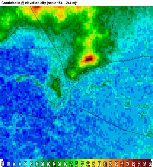
Below is the Elevation map of Condobolin, which displays elevation range with different colors. Scale of the first map is from 184 to 244 m (604 to 801 ft) with average elevation of 195.4 meters (=641 ft) [note 1]
These maps also provides idea of topography and contour of this city, they are displayed at different zoom levels. More info about maps, scale and edge coordinates you can find below images.

| \ | Map #1 | Topo.Map |
| Scale [m] | 184..244 m | × |
| Scale [ft] | 604..801 ft | × |
| Average | 195.4 m = 641 ft | × |
| Width | 8.19 km = 5.1 mi | 262 km = 162.8 mi |
| Height | 8.19 km = 5.1 mi | 262 km = 162.8 mi |
| ↑Max Latitude | -33.051944° | -31.90273° |
| Latitude at center | -33.08877° | -33.08877° |
| ↓Min Latitude | -33.125581° | -34.25902° |
| ← Min Longitude | 147.107445° | 145.74514° |
| Longitude center | 147.15139° | 147.15139° |
| →Max Longitude | 147.195335° | 148.55764° |
Nearby cities:
Cities around Condobolin sort by population:
• Parkes elevation 335 m
95.6 km,  93°
93°
• Forbes 243 m
86.1 km,  112°
112°
• Temora 297 m
155.3 km,  166°
166°
• Narromine 241 m
139.6 km,  46°
46°
• West Wyalong 262 m
93 km,  176°
176°
• Grenfell 389 m
129.9 km,  133°
133°
• Canowindra 304 m
150.1 km, 110°
• Yenda 131 m
155.7 km,  214°
214°
• Hillston 122 m
156.5 km,  253°
253°
• Lake Cargelligo 168 m
76.1 km, 252°
• Trangie 217 m
141.1 km,  33°
33°
• Peak Hill 287 m
105.1 km,  67°
67°
Multilingual:
 En español:
Condobolin elevación 194 m.
 En France:
Condobolin élévation 194 m.
 Auf Deutsch:
Condobolin höhe über dem Meeresspiegel ist 194 m.

Sources and notes:
- [note 1] Map square and city borders are not equal. Map elevation data is calculated only from area inside that square.
- [src 1] Elevation data from geonames database provided with same terms of usage.
- [src 2] The elevation map of Condobolin is generated using elevation data from NASA's 3 arcsec (90m) resolution SRTM data.
- [src 3] Base (background) map © OpenStreetMap contributors tiles are generated by Geofabrik and OpenTopoMap.
Copyright & License:
This Condobolin Elevation Map is licensed under CC BY-SA. You may reuse any part from this page, if you give a proper credit by linking to this URL:
 More info on terms of use page.