Canowindra elevation
Canowindra (New South Wales, Cabonne), Australia elevation is 304 meters and Canowindra elevation in feet is 997 ft above sea level [src 1]. Canowindra is a populated place (feature code) with elevation that is 191 meters (627 ft) bigger than average city elevation in Australia.
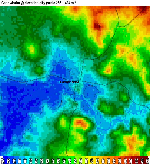
Below is the Elevation map of Canowindra, which displays elevation range with different colors. Scale of the first map is from 285 to 423 m (935 to 1388 ft) with average elevation of 327.9 meters (=1076 ft) [note 1]
These maps also provides idea of topography and contour of this city, they are displayed at different zoom levels. More info about maps, scale and edge coordinates you can find below images.
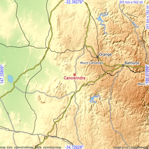
| \ | Map #1 | Topo.Map |
| Scale [m] | 285..423 m | × |
| Scale [ft] | 935..1388 ft | × |
| Average | 327.9 m = 1076 ft | × |
| Width | 8.14 km = 5.1 mi | 260.6 km = 161.9 mi |
| Height | 8.14 km = 5.1 mi | 260.6 km = 161.9 mi |
| ↑Max Latitude | -33.525843° | -32.38276° |
| Latitude at center | -33.56247° | -33.56247° |
| ↓Min Latitude | -33.599081° | -34.72628° |
| ← Min Longitude | 148.620395° | 147.25809° |
| Longitude center | 148.66434° | 148.66434° |
| →Max Longitude | 148.708285° | 150.07059° |
Nearby cities:
Cities around Canowindra sort by population:
• Orange elevation 868 m
50.9 km,  52°
52°
• Parkes 335 m
65.5 km,  316°
316°
• Cowra 302 m
30.5 km,  174°
174°
• Forbes 243 m
64 km,  288°
288°
• Blayney 870 m
54.7 km,  86°
86°
• Windradyne 708 m
83.5 km,  77°
77°
• Molong 532 m
55.7 km,  20°
20°
• Grenfell 389 m
59.2 km,  231°
231°
• Llanarth 681 m
84.3 km, 77°
• Mitchell 712 m
84.1 km, 79°
• Millthorpe 969 m
50 km,  74°
74°
• Abercrombie 669 m
84 km, 76°
Multilingual:
 En español:
Canowindra elevación 304 m.
 En France:
Canowindra élévation 304 m.
 Auf Deutsch:
Canowindra höhe über dem Meeresspiegel ist 304 m.

Sources and notes:
- [note 1] Map square and city borders are not equal. Map elevation data is calculated only from area inside that square.
- [src 1] Elevation data from geonames database provided with same terms of usage.
- [src 2] The elevation map of Canowindra is generated using elevation data from NASA's 3 arcsec (90m) resolution SRTM data.
- [src 3] Base (background) map © OpenStreetMap contributors tiles are generated by Geofabrik and OpenTopoMap.
Copyright & License:
This Canowindra Elevation Map is licensed under CC BY-SA. You may reuse any part from this page, if you give a proper credit by linking to this URL:
 More info on terms of use page.