Cootamundra elevation
Cootamundra (New South Wales, Gundagai), Australia elevation is 332 meters and Cootamundra elevation in feet is 1089 ft above sea level [src 1]. Cootamundra is a populated place (feature code) with elevation that is 219 meters (719 ft) bigger than average city elevation in Australia.
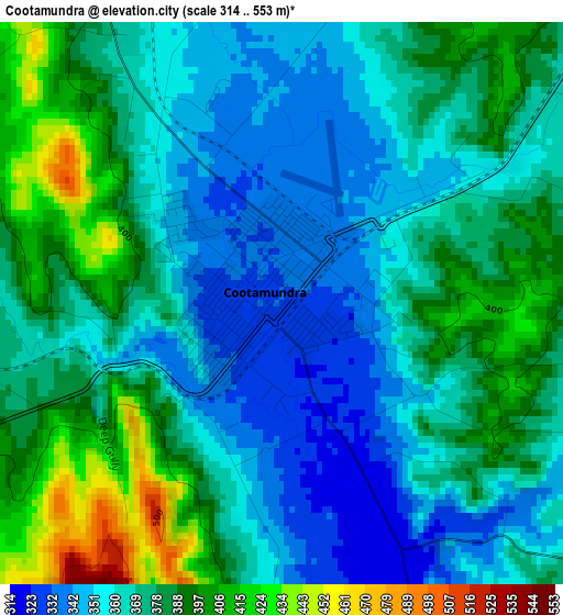
Below is the Elevation map of Cootamundra, which displays elevation range with different colors. Scale of the first map is from 314 to 553 m (1030 to 1814 ft) with average elevation of 372.2 meters (=1221 ft) [note 1]
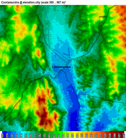
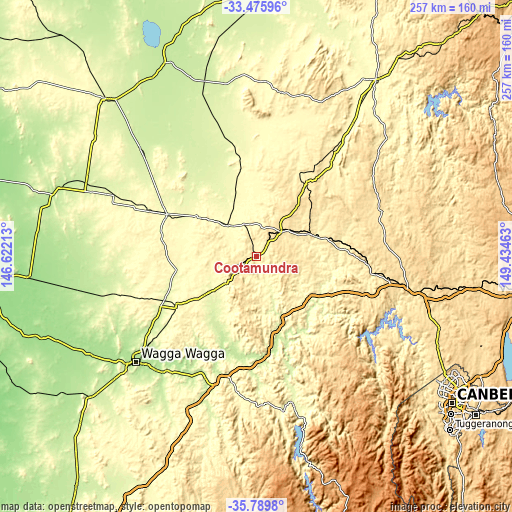
These maps also provides idea of topography and contour of this city, they are displayed at different zoom levels. More info about maps, scale and edge coordinates you can find below images.
| \ | Map #1 | Map #2 | Topo.Map |
| Scale [m] | 314..553 m | 300..567 m | × |
| Scale [ft] | 1030..1814 ft | 984..1860 ft | × |
| Average | 372.2 m = 1221 ft | 395.4 m = 1297 ft | × |
| Width | 8.04 km = 5 mi | 16.08 km = 10 mi | 257.3 km = 159.9 mi |
| Height | 8.04 km = 5 mi | 16.08 km = 10 mi | 257.3 km = 159.9 mi |
| ↑Max Latitude | -34.604787° | -34.568608° | -33.47596° |
| Latitude at center | -34.64095° | -34.64095° | -34.64095° |
| ↓Min Latitude | -34.677097° | -34.713229° | -35.7898° |
| ← Min Longitude | 147.984435° | 147.940489° | 146.62213° |
| Longitude center | 148.02838° | 148.02838° | 148.02838° |
| →Max Longitude | 148.072325° | 148.116271° | 149.43463° |
Nearby cities:
Cities around Cootamundra sort by population:
• Young elevation 438 m
44.2 km,  34°
34°
• Wagga Wagga 201 m
81.8 km,  228°
228°
• Kooringal 216 m
81.4 km, 226°
• Tumut 316 m
76 km,  166°
166°
• Junee 301 m
47.9 km,  238°
238°
• Temora 297 m
50 km,  295°
295°
• Turvey Park 212 m
81.4 km, 228°
• Forest Hill 212 m
76.2 km,  222°
222°
• Estella 203 m
77.8 km, 231°
• Coolamon 247 m
78.5 km,  255°
255°
• Gundagai 226 m
47.5 km, 171°
• Boorowa 487 m
67 km,  70°
70°
Multilingual:
 En español:
Cootamundra elevación 332 m.
 En France:
Cootamundra élévation 332 m.
 Auf Deutsch:
Cootamundra höhe über dem Meeresspiegel ist 332 m.

Sources and notes:
- [note 1] Map square and city borders are not equal. Map elevation data is calculated only from area inside that square.
- [src 1] Elevation data from geonames database provided with same terms of usage.
- [src 2] The elevation map of Cootamundra is generated using elevation data from NASA's 3 arcsec (90m) resolution SRTM data.
- [src 3] Base (background) map © OpenStreetMap contributors tiles are generated by Geofabrik and OpenTopoMap.
Copyright & License:
This Cootamundra Elevation Map is licensed under CC BY-SA. You may reuse any part from this page, if you give a proper credit by linking to this URL:
 More info on terms of use page.