Darlinghurst elevation
Darlinghurst (New South Wales, City of Sydney), Australia elevation is 53 meters and Darlinghurst elevation in feet is 174 ft above sea level [src 1]. Darlinghurst is a section of populated place (feature code) with elevation that is 60 meters (197 ft) smaller than average city elevation in Australia.
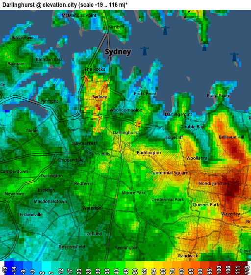
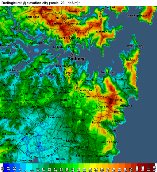
Below is the Elevation map of Darlinghurst, which displays elevation range with different colors. Scale of the first map is from -19 to 116 m (-62 to 381 ft) with average elevation of 35.2 meters (=115 ft) [note 1]
These maps also provides idea of topography and contour of this city, they are displayed at different zoom levels. More info about maps, scale and edge coordinates you can find below images.
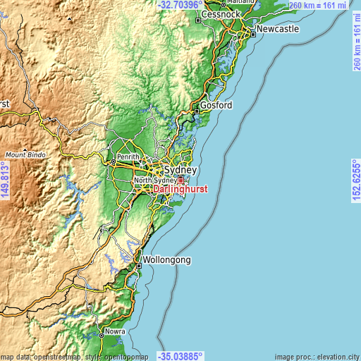
| \ | Map #1 | Map #2 | Topo.Map |
| Scale [m] | -19..116 m | -20..116 m | × |
| Scale [ft] | -62..381 ft | -66..381 ft | × |
| Average | 35.2 m = 115 ft | 33.3 m = 109 ft | × |
| Width | 8.11 km = 5 mi | 16.23 km = 10.1 mi | 259.6 km = 161.3 mi |
| Height | 8.11 km = 5 mi | 16.23 km = 10.1 mi | 259.6 km = 161.3 mi |
| ↑Max Latitude | -33.842898° | -33.806391° | -32.70396° |
| Latitude at center | -33.87939° | -33.87939° | -33.87939° |
| ↓Min Latitude | -33.915866° | -33.952327° | -35.03885° |
| ← Min Longitude | 151.175305° | 151.131359° | 149.813° |
| Longitude center | 151.21925° | 151.21925° | 151.21925° |
| →Max Longitude | 151.263195° | 151.307141° | 152.6255° |
Nearby cities:
Cities around Darlinghurst sort by population:
• Sydney elevation 1 m
1.7 km,  319°
319°
• Sydney Central Business District 76 m
1.9 km,  326°
326°
• Surry Hills 41 m
0.8 km,  230°
230°
• Redfern 39 m
2 km,  223°
223°
• Paddington 51 m
1.3 km,  115°
115°
• Potts Point 17 m
1.5 km,  23°
23°
• Haymarket 24 m
1.3 km,  273°
273°
• Woollahra 67 m
1.9 km, 119°
• Elizabeth Bay 46 m
1.1 km,  40°
40°
• Woolloomooloo 6 m
1 km,  2°
2°
• Edgecliff 48 m
1.6 km,  90°
90°
• Rushcutters Bay 10 m
1 km,  57°
57°
Multilingual:
 En español:
Darlinghurst elevación 53 m.
 En France:
Darlinghurst élévation 53 m.
 Auf Deutsch:
Darlinghurst höhe über dem Meeresspiegel ist 53 m.

Sources and notes:
- [note 1] Map square and city borders are not equal. Map elevation data is calculated only from area inside that square.
- [src 1] Elevation data from geonames database provided with same terms of usage.
- [src 2] The elevation map of Darlinghurst is generated using elevation data from NASA's 3 arcsec (90m) resolution SRTM data.
- [src 3] Base (background) map © OpenStreetMap contributors tiles are generated by Geofabrik and OpenTopoMap.
Copyright & License:
This Darlinghurst Elevation Map is licensed under CC BY-SA. You may reuse any part from this page, if you give a proper credit by linking to this URL:
 More info on terms of use page.