Redfern elevation
Redfern (New South Wales, City of Sydney), Australia elevation is 39 meters and Redfern elevation in feet is 128 ft above sea level [src 1]. Redfern is a section of populated place (feature code) with elevation that is 74 meters (243 ft) smaller than average city elevation in Australia.
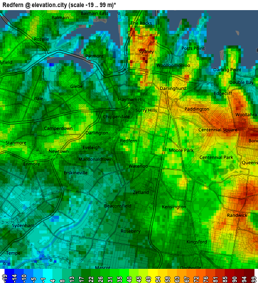
Below is the Elevation map of Redfern, which displays elevation range with different colors. Scale of the first map is from -19 to 99 m (-62 to 325 ft) with average elevation of 28.2 meters (=93 ft) [note 1]
These maps also provides idea of topography and contour of this city, they are displayed at different zoom levels. More info about maps, scale and edge coordinates you can find below images.
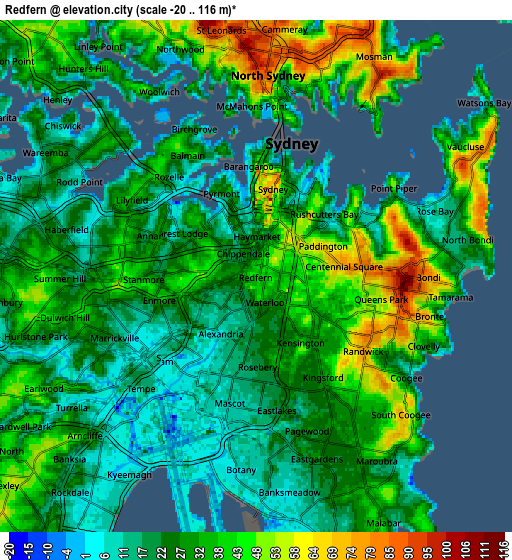
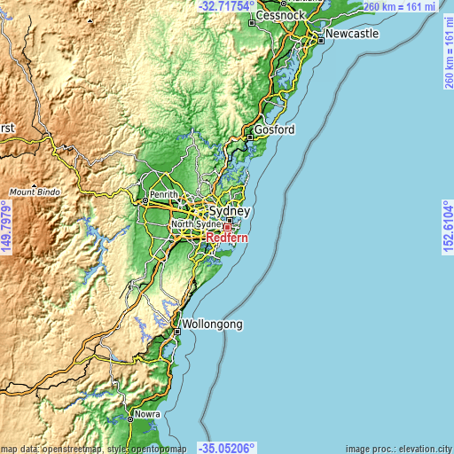
| \ | Map #1 | Map #2 | Topo.Map |
| Scale [m] | -19..99 m | -20..116 m | × |
| Scale [ft] | -62..325 ft | -66..381 ft | × |
| Average | 28.2 m = 93 ft | 29.5 m = 97 ft | × |
| Width | 8.11 km = 5 mi | 16.22 km = 10.1 mi | 259.6 km = 161.3 mi |
| Height | 8.11 km = 5 mi | 16.22 km = 10.1 mi | 259.6 km = 161.3 mi |
| ↑Max Latitude | -33.856304° | -33.819802° | -32.71754° |
| Latitude at center | -33.89279° | -33.89279° | -33.89279° |
| ↓Min Latitude | -33.92926° | -33.965715° | -35.05206° |
| ← Min Longitude | 151.160205° | 151.116259° | 149.7979° |
| Longitude center | 151.20415° | 151.20415° | 151.20415° |
| →Max Longitude | 151.248095° | 151.292041° | 152.6104° |
Nearby cities:
Cities around Redfern sort by population:
• Surry Hills elevation 41 m
1.3 km,  38°
38°
• Newtown 37 m
2.5 km,  255°
255°
• Darlinghurst 53 m
2 km, 43°
• Glebe 29 m
2.4 km,  310°
310°
• Camperdown 24 m
2.6 km,  277°
277°
• Zetland 23 m
1.7 km,  165°
165°
• Haymarket 24 m
1.6 km,  3°
3°
• Chippendale 21 m
0.9 km,  317°
317°
• Ultimo 30 m
1.8 km,  339°
339°
• Alexandria 1 m
0.9 km,  208°
208°
• Erskineville 12 m
2 km,  237°
237°
• Darlington 28 m
0.8 km, 283°
Multilingual:
 En español:
Redfern elevación 39 m.
 En France:
Redfern élévation 39 m.


Sources and notes:
- [note 1] Map square and city borders are not equal. Map elevation data is calculated only from area inside that square.
- [src 1] Elevation data from geonames database provided with same terms of usage.
- [src 2] The elevation map of Redfern is generated using elevation data from NASA's 3 arcsec (90m) resolution SRTM data.
- [src 3] Base (background) map © OpenStreetMap contributors tiles are generated by Geofabrik and OpenTopoMap.
Copyright & License:
This Redfern Elevation Map is licensed under CC BY-SA. You may reuse any part from this page, if you give a proper credit by linking to this URL:
 More info on terms of use page.