Horsham elevation
Horsham (Victoria), Australia elevation is 133 meters and Horsham elevation in feet is 436 ft above sea level [src 1]. Horsham is a populated place (feature code) with elevation that is 20 meters (66 ft) bigger than average city elevation in Australia.
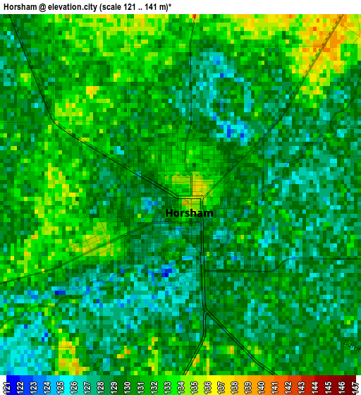
Below is the Elevation map of Horsham, which displays elevation range with different colors. Scale of the first map is from 121 to 141 m (397 to 463 ft) with average elevation of 129.9 meters (=426 ft) [note 1]
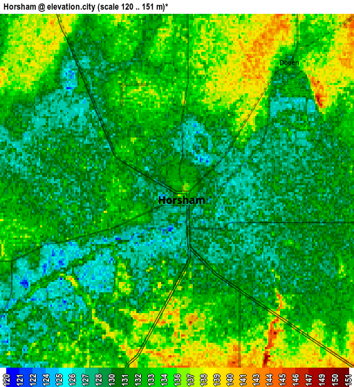
These maps also provides idea of topography and contour of this city, they are displayed at different zoom levels. More info about maps, scale and edge coordinates you can find below images.
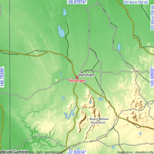
| \ | Map #1 | Map #2 | Topo.Map |
| Scale [m] | 121..141 m | 120..151 m | × |
| Scale [ft] | 397..463 ft | 394..495 ft | × |
| Average | 129.9 m = 426 ft | 131.9 m = 433 ft | × |
| Width | 7.83 km = 4.9 mi | 15.67 km = 9.7 mi | 250.7 km = 155.8 mi |
| Height | 7.83 km = 4.9 mi | 15.67 km = 9.7 mi | 250.7 km = 155.8 mi |
| ↑Max Latitude | -36.676073° | -36.64082° | -35.57574° |
| Latitude at center | -36.71131° | -36.71131° | -36.71131° |
| ↓Min Latitude | -36.746531° | -36.781736° | -37.83034° |
| ← Min Longitude | 142.155865° | 142.111919° | 140.79356° |
| Longitude center | 142.19981° | 142.19981° | 142.19981° |
| →Max Longitude | 142.243755° | 142.287701° | 143.60606° |
Nearby cities:
Cities around Horsham sort by population:
• Hamilton elevation 189 m
115.9 km,  187°
187°
• Ararat 325 m
90.8 km,  134°
134°
• Stawell 254 m
64.4 km, 126°
• Warracknabeal 109 m
53.8 km,  18°
18°
• Nhill 132 m
64.6 km,  310°
310°
• Dimboola 111 m
32 km,  332°
332°
• Casterton 49 m
120.1 km,  216°
216°
• Beaufort 391 m
132 km, 127°
• Donald 114 m
79.5 km,  61°
61°
• Haven 141 m
5.5 km, 185°
• Avoca 239 m
120.9 km,  110°
110°
• Charlton 135 m
114.1 km, 64°
Multilingual:
 En español:
Horsham elevación 133 m.
 En France:
Horsham élévation 133 m.


Sources and notes:
- [note 1] Map square and city borders are not equal. Map elevation data is calculated only from area inside that square.
- [src 1] Elevation data from geonames database provided with same terms of usage.
- [src 2] The elevation map of Horsham is generated using elevation data from NASA's 3 arcsec (90m) resolution SRTM data.
- [src 3] Base (background) map © OpenStreetMap contributors tiles are generated by Geofabrik and OpenTopoMap.
Copyright & License:
This Horsham Elevation Map is licensed under CC BY-SA. You may reuse any part from this page, if you give a proper credit by linking to this URL:
 More info on terms of use page.