Ararat elevation
Ararat (Victoria), Australia elevation is 325 meters and Ararat elevation in feet is 1066 ft above sea level [src 1]. Ararat is a populated place (feature code) with elevation that is 212 meters (696 ft) bigger than average city elevation in Australia.
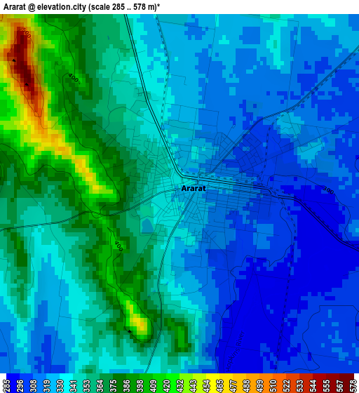
Below is the Elevation map of Ararat, which displays elevation range with different colors. Scale of the first map is from 285 to 578 m (935 to 1896 ft) with average elevation of 340.7 meters (=1118 ft) [note 1]
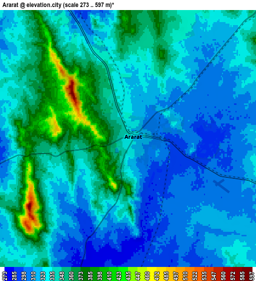
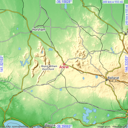
These maps also provides idea of topography and contour of this city, they are displayed at different zoom levels. More info about maps, scale and edge coordinates you can find below images.
| \ | Map #1 | Map #2 | Topo.Map |
| Scale [m] | 285..578 m | 273..597 m | × |
| Scale [ft] | 935..1896 ft | 896..1959 ft | × |
| Average | 340.7 m = 1118 ft | 333.1 m = 1093 ft | × |
| Width | 7.78 km = 4.8 mi | 15.55 km = 9.7 mi | 248.8 km = 154.6 mi |
| Height | 7.78 km = 4.8 mi | 15.55 km = 9.7 mi | 248.8 km = 154.6 mi |
| ↑Max Latitude | -37.250448° | -37.215459° | -36.15828° |
| Latitude at center | -37.28542° | -37.28542° | -37.28542° |
| ↓Min Latitude | -37.320376° | -37.355316° | -38.39593° |
| ← Min Longitude | 142.883335° | 142.839389° | 141.52103° |
| Longitude center | 142.92728° | 142.92728° | 142.92728° |
| →Max Longitude | 142.971225° | 143.015171° | 144.33353° |
Nearby cities:
Cities around Ararat sort by population:
• Maryborough elevation 241 m
76.7 km,  69°
69°
• Stawell 254 m
28.6 km,  333°
333°
• Miners Rest 432 m
80.2 km,  105°
105°
• Clunes 309 m
76 km,  90°
90°
• Lake Gardens 464 m
83.7 km, 110°
• Beaufort 391 m
43.4 km, 111°
• Smythes Creek 399 m
83.3 km, 114°
• Haddon 386 m
78 km,  116°
116°
• Avoca 239 m
53 km, 65°
• Ross Creek 451 m
83.2 km, 119°
• Carisbrook 197 m
83.1 km, 71°
• Smythesdale 364 m
77.9 km, 120°
Multilingual:
 En español:
Ararat elevación 325 m.
 En France:
Ararat élévation 325 m.


Sources and notes:
- [note 1] Map square and city borders are not equal. Map elevation data is calculated only from area inside that square.
- [src 1] Elevation data from geonames database provided with same terms of usage.
- [src 2] The elevation map of Ararat is generated using elevation data from NASA's 3 arcsec (90m) resolution SRTM data.
- [src 3] Base (background) map © OpenStreetMap contributors tiles are generated by Geofabrik and OpenTopoMap.
Copyright & License:
This Ararat Elevation Map is licensed under CC BY-SA. You may reuse any part from this page, if you give a proper credit by linking to this URL:
 More info on terms of use page.