Mount Colah elevation
Mount Colah (New South Wales, Hornsby Shire), Australia elevation is 164 meters and Mount Colah elevation in feet is 538 ft above sea level [src 1]. Mount Colah is a section of populated place (feature code) with elevation that is 51 meters (167 ft) bigger than average city elevation in Australia.
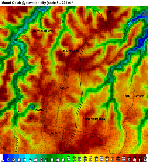
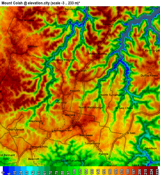
Below is the Elevation map of Mount Colah, which displays elevation range with different colors. Scale of the first map is from 5 to 221 m (16 to 725 ft) with average elevation of 154.3 meters (=506 ft) [note 1]
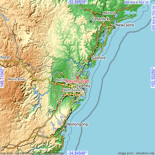
These maps also provides idea of topography and contour of this city, they are displayed at different zoom levels. More info about maps, scale and edge coordinates you can find below images.
| \ | Map #1 | Map #2 | Topo.Map |
| Scale [m] | 5..221 m | -3..233 m | × |
| Scale [ft] | 16..725 ft | -10..764 ft | × |
| Average | 154.3 m = 506 ft | 150.4 m = 493 ft | × |
| Width | 8.13 km = 5.1 mi | 16.26 km = 10.1 mi | 260.2 km = 161.7 mi |
| Height | 8.13 km = 5.1 mi | 16.26 km = 10.1 mi | 260.2 km = 161.7 mi |
| ↑Max Latitude | -33.646755° | -33.610164° | -32.50525° |
| Latitude at center | -33.68333° | -33.68333° | -33.68333° |
| ↓Min Latitude | -33.71989° | -33.756434° | -34.84548° |
| ← Min Longitude | 151.072725° | 151.028779° | 149.71042° |
| Longitude center | 151.11667° | 151.11667° | 151.11667° |
| →Max Longitude | 151.160615° | 151.204561° | 152.52292° |
Nearby cities:
Cities around Mount Colah sort by population:
• Hornsby elevation 186 m
2.7 km,  217°
217°
• Wahroonga 206 m
3.9 km,  181°
181°
• Hornsby Heights 185 m
2.5 km,  302°
302°
• Waitara 192 m
3.3 km,  201°
201°
• Normanhurst 178 m
4.9 km, 203°
• Westleigh 156 m
5.2 km,  232°
232°
• North Turramurra 165 m
4.3 km,  140°
140°
• Asquith 167 m
0.4 km, 184°
• St Ives Chase 160 m
5 km,  117°
117°
• Warrawee 184 m
5.1 km, 175°
• North Wahroonga 202 m
2.5 km,  166°
166°
• Mount Kuring-Gai 213 m
4.7 km,  13°
13°
Multilingual:
 En español:
Mount Colah elevación 164 m.
 En France:
Mount Colah élévation 164 m.
 Auf Deutsch:
Mount Colah höhe über dem Meeresspiegel ist 164 m.

Sources and notes:
- [note 1] Map square and city borders are not equal. Map elevation data is calculated only from area inside that square.
- [src 1] Elevation data from geonames database provided with same terms of usage.
- [src 2] The elevation map of Mount Colah is generated using elevation data from NASA's 3 arcsec (90m) resolution SRTM data.
- [src 3] Base (background) map © OpenStreetMap contributors tiles are generated by Geofabrik and OpenTopoMap.
Copyright & License:
This Mount Colah Elevation Map is licensed under CC BY-SA. You may reuse any part from this page, if you give a proper credit by linking to this URL:
 More info on terms of use page.