Mount Macedon elevation
Mount Macedon (Victoria, Macedon Ranges), Australia elevation is 600 meters and Mount Macedon elevation in feet is 1969 ft above sea level [src 1]. Mount Macedon is a populated place (feature code) with elevation that is 487 meters (1598 ft) bigger than average city elevation in Australia.
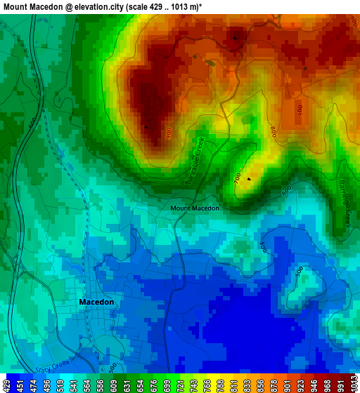
Below is the Elevation map of Mount Macedon, which displays elevation range with different colors. Scale of the first map is from 429 to 1013 m (1407 to 3323 ft) with average elevation of 631.4 meters (=2072 ft) [note 1]
These maps also provides idea of topography and contour of this city, they are displayed at different zoom levels. More info about maps, scale and edge coordinates you can find below images.
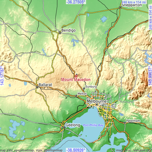
| \ | Map #1 | Topo.Map |
| Scale [m] | 429..1013 m | × |
| Scale [ft] | 1407..3323 ft | × |
| Average | 631.4 m = 2072 ft | × |
| Width | 7.76 km = 4.8 mi | 248.4 km = 154.3 mi |
| Height | 7.76 km = 4.8 mi | 248.4 km = 154.3 mi |
| ↑Max Latitude | -37.365561° | -36.27505° |
| Latitude at center | -37.40048° | -37.40048° |
| ↓Min Latitude | -37.435382° | -38.50926° |
| ← Min Longitude | 144.540175° | 143.17787° |
| Longitude center | 144.58412° | 144.58412° |
| →Max Longitude | 144.628065° | 145.99037° |
Nearby cities:
Cities around Mount Macedon sort by population:
• Sunbury elevation 220 m
23.3 km,  147°
147°
• Melton West 140 m
30.9 km,  182°
182°
• Kurunjang 142 m
30.6 km, 177°
• Gisborne 421 m
9.8 km,  174°
174°
• Kyneton 514 m
20.9 km,  325°
325°
• Woodend 558 m
7 km,  316°
316°
• Romsey 492 m
15.1 km,  68°
68°
• Diggers Rest 201 m
27.7 km, 154°
• Lancefield 480 m
19.2 km,  44°
44°
• New Gisborne 470 m
6.8 km, 168°
• Macedon 508 m
2.9 km,  221°
221°
• Trentham 703 m
23.2 km,  273°
273°
Multilingual:
 En español:
Mount Macedon elevación 600 m.
 En France:
Mount Macedon élévation 600 m.
 Auf Deutsch:
Mount Macedon höhe über dem Meeresspiegel ist 600 m.

Sources and notes:
- [note 1] Map square and city borders are not equal. Map elevation data is calculated only from area inside that square.
- [src 1] Elevation data from geonames database provided with same terms of usage.
- [src 2] The elevation map of Mount Macedon is generated using elevation data from NASA's 3 arcsec (90m) resolution SRTM data.
- [src 3] Base (background) map © OpenStreetMap contributors tiles are generated by Geofabrik and OpenTopoMap.
Copyright & License:
This Mount Macedon Elevation Map is licensed under CC BY-SA. You may reuse any part from this page, if you give a proper credit by linking to this URL:
 More info on terms of use page.