Warragul elevation
Warragul (Victoria, Baw Baw), Australia elevation is 135 meters and Warragul elevation in feet is 443 ft above sea level [src 1]. Warragul is a populated place (feature code) with elevation that is 22 meters (72 ft) bigger than average city elevation in Australia.
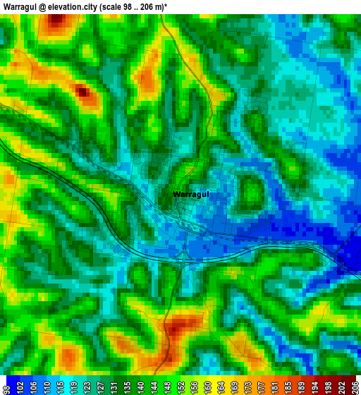
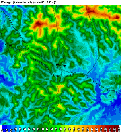
Below is the Elevation map of Warragul, which displays elevation range with different colors. Scale of the first map is from 98 to 206 m (322 to 676 ft) with average elevation of 134.6 meters (=442 ft) [note 1]
These maps also provides idea of topography and contour of this city, they are displayed at different zoom levels. More info about maps, scale and edge coordinates you can find below images.
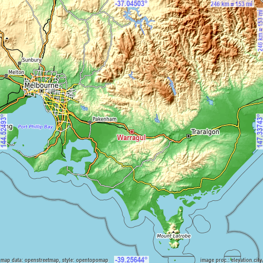
| \ | Map #1 | Map #2 | Topo.Map |
| Scale [m] | 98..206 m | 80..250 m | × |
| Scale [ft] | 322..676 ft | 262..820 ft | × |
| Average | 134.6 m = 442 ft | 131.8 m = 432 ft | × |
| Width | 7.68 km = 4.8 mi | 15.37 km = 9.6 mi | 245.9 km = 152.8 mi |
| Height | 7.68 km = 4.8 mi | 15.37 km = 9.6 mi | 245.9 km = 152.8 mi |
| ↑Max Latitude | -38.124558° | -38.089979° | -37.04503° |
| Latitude at center | -38.15912° | -38.15912° | -38.15912° |
| ↓Min Latitude | -38.193666° | -38.228195° | -39.25644° |
| ← Min Longitude | 145.887235° | 145.843289° | 144.52493° |
| Longitude center | 145.93118° | 145.93118° | 145.93118° |
| →Max Longitude | 145.975125° | 146.019071° | 147.33743° |
Nearby cities:
Cities around Warragul sort by population:
• Drouin elevation 143 m
6.8 km,  291°
291°
• Moe 76 m
28.9 km,  94°
94°
• Newborough 76 m
31.6 km, 92°
• Korumburra 226 m
31.8 km,  197°
197°
• Trafalgar 72 m
20.2 km,  105°
105°
• Bunyip 47 m
20 km, 289°
• Mirboo North 245 m
33.6 km,  143°
143°
• Longwarry 45 m
15.1 km, 289°
• Garfield 50 m
23.7 km, 288°
• Yarragon 86 m
12.4 km, 114°
• Nyora 122 m
29.8 km,  229°
229°
• Neerim South 258 m
16 km,  7°
7°
Multilingual:
 En español:
Warragul elevación 135 m.
 En France:
Warragul élévation 135 m.
 Auf Deutsch:
Warragul höhe über dem Meeresspiegel ist 135 m.

Sources and notes:
- [note 1] Map square and city borders are not equal. Map elevation data is calculated only from area inside that square.
- [src 1] Elevation data from geonames database provided with same terms of usage.
- [src 2] The elevation map of Warragul is generated using elevation data from NASA's 3 arcsec (90m) resolution SRTM data.
- [src 3] Base (background) map © OpenStreetMap contributors tiles are generated by Geofabrik and OpenTopoMap.
Copyright & License:
This Warragul Elevation Map is licensed under CC BY-SA. You may reuse any part from this page, if you give a proper credit by linking to this URL:
 More info on terms of use page.