Meningie elevation
Meningie (South Australia, The Coorong), Australia elevation is 4 meters and Meningie elevation in feet is 13 ft above sea level [src 1]. Meningie is a populated place (feature code) with elevation that is 109 meters (358 ft) smaller than average city elevation in Australia.
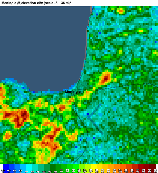
Below is the Elevation map of Meningie, which displays elevation range with different colors. Scale of the first map is from -5 to 36 m (-16 to 118 ft) with average elevation of 8.8 meters (=29 ft) [note 1]
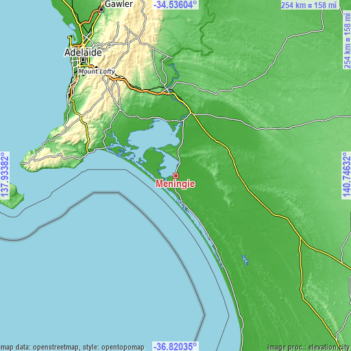
These maps also provides idea of topography and contour of this city, they are displayed at different zoom levels. More info about maps, scale and edge coordinates you can find below images.
| \ | Map #1 | Topo.Map |
| Scale [m] | -5..36 m | × |
| Scale [ft] | -16..118 ft | × |
| Average | 8.8 m = 29 ft | × |
| Width | 7.94 km = 4.9 mi | 254 km = 157.8 mi |
| Height | 7.94 km = 4.9 mi | 254 km = 157.8 mi |
| ↑Max Latitude | -35.650669° | -34.53604° |
| Latitude at center | -35.68637° | -35.68637° |
| ↓Min Latitude | -35.722055° | -36.82035° |
| ← Min Longitude | 139.296125° | 137.93382° |
| Longitude center | 139.34007° | 139.34007° |
| →Max Longitude | 139.384015° | 140.74632° |
Nearby cities:
Cities around Meningie sort by population:
• Murray Bridge elevation 36 m
63.3 km,  354°
354°
• Strathalbyn 72 m
62.4 km,  319°
319°
• Encounter Bay 8 m
68 km,  280°
280°
• Victor Harbor 8 m
66.7 km, 283°
• Goolwa 4 m
54.5 km,  292°
292°
• Hayborough 29 m
64.7 km, 285°
• Port Elliot 25 m
62.2 km, 286°
• Goolwa Beach 12 m
55.1 km, 291°
• McCracken 18 m
66.2 km, 284°
• Tailem Bend 22 m
49.4 km,  12°
12°
• Hindmarsh Island 6 m
47 km, 294°
• Middleton 25 m
60.8 km, 288°
Multilingual:
 En español:
Meningie elevación 4 m.
 En France:
Meningie élévation 4 m.


Sources and notes:
- [note 1] Map square and city borders are not equal. Map elevation data is calculated only from area inside that square.
- [src 1] Elevation data from geonames database provided with same terms of usage.
- [src 2] The elevation map of Meningie is generated using elevation data from NASA's 3 arcsec (90m) resolution SRTM data.
- [src 3] Base (background) map © OpenStreetMap contributors tiles are generated by Geofabrik and OpenTopoMap.
Copyright & License:
This Meningie Elevation Map is licensed under CC BY-SA. You may reuse any part from this page, if you give a proper credit by linking to this URL:
 More info on terms of use page.