Murray Bridge elevation
Murray Bridge (South Australia), Australia elevation is 36 meters and Murray Bridge elevation in feet is 118 ft above sea level [src 1]. Murray Bridge is a populated place (feature code) with elevation that is 77 meters (253 ft) smaller than average city elevation in Australia.
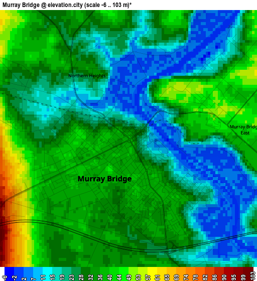
Below is the Elevation map of Murray Bridge, which displays elevation range with different colors. Scale of the first map is from -6 to 103 m (-20 to 338 ft) with average elevation of 28.9 meters (=95 ft) [note 1]
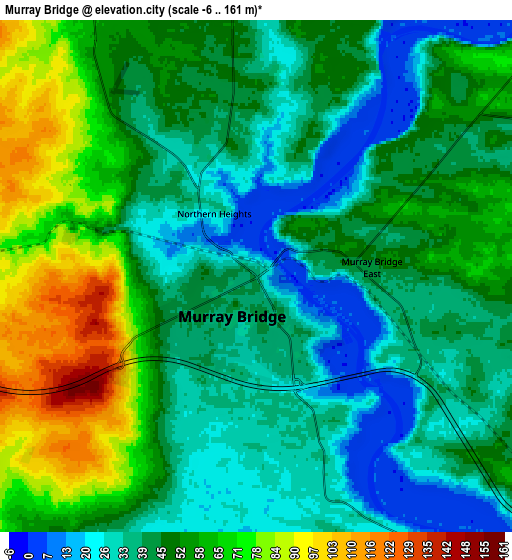
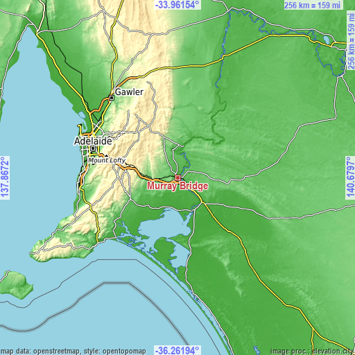
These maps also provides idea of topography and contour of this city, they are displayed at different zoom levels. More info about maps, scale and edge coordinates you can find below images.
| \ | Map #1 | Map #2 | Topo.Map |
| Scale [m] | -6..103 m | -6..161 m | × |
| Scale [ft] | -20..338 ft | -20..528 ft | × |
| Average | 28.9 m = 95 ft | 48.3 m = 158 ft | × |
| Width | 7.99 km = 5 mi | 15.99 km = 9.9 mi | 255.8 km = 158.9 mi |
| Height | 7.99 km = 5 mi | 15.99 km = 9.9 mi | 255.8 km = 158.9 mi |
| ↑Max Latitude | -35.083907° | -35.047938° | -33.96154° |
| Latitude at center | -35.11986° | -35.11986° | -35.11986° |
| ↓Min Latitude | -35.155797° | -35.191718° | -36.26194° |
| ← Min Longitude | 139.229505° | 139.185559° | 137.8672° |
| Longitude center | 139.27345° | 139.27345° | 139.27345° |
| →Max Longitude | 139.317395° | 139.361341° | 140.6797° |
Nearby cities:
Cities around Murray Bridge sort by population:
• Mount Barker elevation 322 m
37.5 km,  279°
279°
• Strathalbyn 72 m
38 km,  245°
245°
• Nairne 369 m
34.3 km,  286°
286°
• Hahndorf 341 m
43.6 km, 283°
• Mannum 33 m
22.9 km,  6°
6°
• Woodside 369 m
40.4 km,  297°
297°
• Lobethal 422 m
43.5 km, 303°
• Little Hampton 362 m
38.2 km, 283°
• Tailem Bend 22 m
22.1 km,  131°
131°
• Balhannah 334 m
43.2 km, 289°
• Macclesfield 297 m
40.2 km,  261°
261°
• Echunga 367 m
43.5 km,  272°
272°
Multilingual:
 En español:
Murray Bridge elevación 36 m.
 En France:
Murray Bridge élévation 36 m.
 Auf Deutsch:
Murray Bridge höhe über dem Meeresspiegel ist 36 m.

Sources and notes:
- [note 1] Map square and city borders are not equal. Map elevation data is calculated only from area inside that square.
- [src 1] Elevation data from geonames database provided with same terms of usage.
- [src 2] The elevation map of Murray Bridge is generated using elevation data from NASA's 3 arcsec (90m) resolution SRTM data.
- [src 3] Base (background) map © OpenStreetMap contributors tiles are generated by Geofabrik and OpenTopoMap.
Copyright & License:
This Murray Bridge Elevation Map is licensed under CC BY-SA. You may reuse any part from this page, if you give a proper credit by linking to this URL:
 More info on terms of use page.