Mauer elevation
Mauer (Carinthia, Politischer Bezirk Sankt Veit an der Glan), Austria elevation is 750 meters and Mauer elevation in feet is 2461 ft above sea level [src 1]. Mauer is a seat of a third-order administrative division (feature code) with elevation that is 241 meters (791 ft) bigger than average city elevation in Austria.
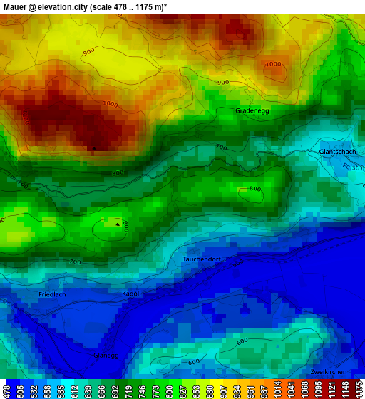
Below is the Elevation map of Mauer, which displays elevation range with different colors. Scale of the first map is from 478 to 1175 m (1568 to 3855 ft) with average elevation of 720 meters (=2362 ft) [note 1]
These maps also provides idea of topography and contour of this city, they are displayed at different zoom levels. More info about maps, scale and edge coordinates you can find below images.
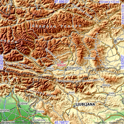
| \ | Map #1 | Topo.Map |
| Scale [m] | 478..1175 m | × |
| Scale [ft] | 1568..3855 ft | × |
| Average | 720 m = 2362 ft | × |
| Width | 6.7 km = 4.2 mi | 214.3 km = 133.2 mi |
| Height | 6.7 km = 4.2 mi | 214.3 km = 133.2 mi |
| ↑Max Latitude | 46.771147° | 47.69613° |
| Latitude at center | 46.74104° | 46.74104° |
| ↓Min Latitude | 46.710916° | 45.76872° |
| ← Min Longitude | 14.185425° | 12.82312° |
| Longitude center | 14.22937° | 14.22937° |
| →Max Longitude | 14.273315° | 15.63562° |
Nearby cities:
Cities around Mauer sort by population:
• Sankt Veit an der Glan elevation 485 m
10.4 km,  73°
73°
• Wölfnitz 458 m
8.6 km,  165°
165°
• Feldkirchen in Kärnten 543 m
10.4 km,  259°
259°
• Maria Saal 507 m
11.3 km,  126°
126°
• Moosburg 500 m
10.2 km,  204°
204°
• Waiern 590 m
11.3 km, 263°
• Liebenfels 490 m
4.4 km,  94°
94°
• Glanegg 529 m
3.1 km,  228°
228°
• Steuerberg 796 m
10.3 km,  300°
300°
• Seitenberg 641 m
10.8 km,  274°
274°
• Mautbrücken 501 m
3.5 km, 229°
• Frauenstein 1038 m
9.5 km,  31°
31°
Multilingual:
 En español:
Mauer elevación 750 m.
 En France:
Mauer élévation 750 m.


Sources and notes:
- [note 1] Map square and city borders are not equal. Map elevation data is calculated only from area inside that square.
- [src 1] Elevation data from geonames database provided with same terms of usage.
- [src 2] The elevation map of Mauer is generated using elevation data from NASA's 3 arcsec (90m) resolution SRTM data.
- [src 3] Base (background) map © OpenStreetMap contributors tiles are generated by Geofabrik and OpenTopoMap.
Copyright & License:
This Mauer Elevation Map is licensed under CC BY-SA. You may reuse any part from this page, if you give a proper credit by linking to this URL:
 More info on terms of use page.