Sankt Veit an der Glan elevation
Sankt Veit an der Glan (Carinthia, Politischer Bezirk Sankt Veit an der Glan), Austria elevation is 485 meters and Sankt Veit an der Glan elevation in feet is 1591 ft above sea level [src 1]. Sankt Veit an der Glan is a seat of a second-order administrative division (feature code) with elevation that is 24 meters (79 ft) smaller than average city elevation in Austria.
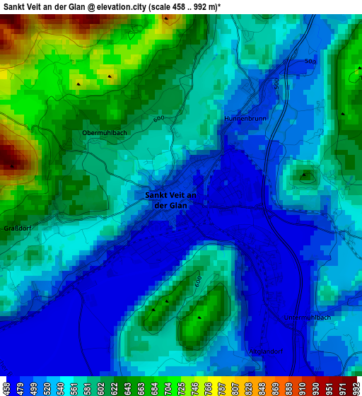
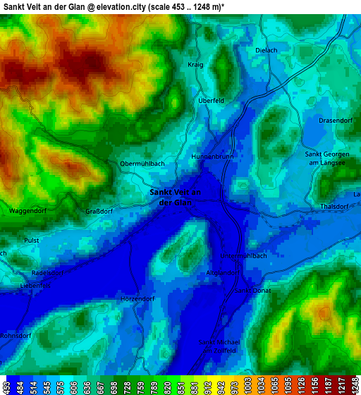
Below is the Elevation map of Sankt Veit an der Glan, which displays elevation range with different colors. Scale of the first map is from 458 to 992 m (1503 to 3255 ft) with average elevation of 569.5 meters (=1868 ft) [note 1]
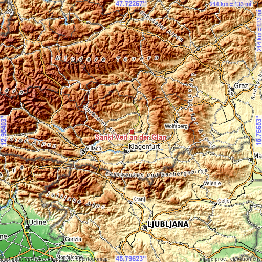
These maps also provides idea of topography and contour of this city, they are displayed at different zoom levels. More info about maps, scale and edge coordinates you can find below images.
| \ | Map #1 | Map #2 | Topo.Map |
| Scale [m] | 458..992 m | 453..1248 m | × |
| Scale [ft] | 1503..3255 ft | 1486..4094 ft | × |
| Average | 569.5 m = 1868 ft | 665.9 m = 2185 ft | × |
| Width | 6.69 km = 4.2 mi | 13.39 km = 8.3 mi | 214.2 km = 133.1 mi |
| Height | 6.69 km = 4.2 mi | 13.39 km = 8.3 mi | 214.2 km = 133.1 mi |
| ↑Max Latitude | 46.798152° | 46.828227° | 47.72267° |
| Latitude at center | 46.76806° | 46.76806° | 46.76806° |
| ↓Min Latitude | 46.737951° | 46.707825° | 45.79623° |
| ← Min Longitude | 14.316335° | 14.272389° | 12.95403° |
| Longitude center | 14.36028° | 14.36028° | 14.36028° |
| →Max Longitude | 14.404225° | 14.448171° | 15.76653° |
Nearby cities:
Cities around Sankt Veit an der Glan sort by population:
• Annabichl elevation 454 m
13.5 km,  194°
194°
• Launsdorf 564 m
7 km,  87°
87°
• Maria Saal 507 m
9.7 km, 185°
• Treibach 611 m
13.6 km,  36°
36°
• Gurk 665 m
12.9 km,  336°
336°
• Liebenfels 490 m
6.5 km,  239°
239°
• Kappel am Krappfeld 590 m
12.4 km,  50°
50°
• Glanegg 529 m
13.3 km,  247°
247°
• Mölbling 570 m
10.7 km,  31°
31°
• St. Georgen am Längsee 596 m
5.5 km,  75°
75°
• Frauenstein 1038 m
7.2 km,  315°
315°
• Mauer 750 m
10.4 km, 253°
Multilingual:
 En español:
Sankt Veit an der Glan elevación 485 m.
 En France:
Sankt Veit an der Glan élévation 485 m.
 Auf Deutsch:
Sankt Veit an der Glan höhe über dem Meeresspiegel ist 485 m.
 На русском:
Санкт-Вайт-ан-дер-Глан, Санкт-Файт-ан-дер-Глан высота над уровнем моря 485 м
Sources and notes:
- [note 1] Map square and city borders are not equal. Map elevation data is calculated only from area inside that square.
- [src 1] Elevation data from geonames database provided with same terms of usage.
- [src 2] The elevation map of Sankt Veit an der Glan is generated using elevation data from NASA's 3 arcsec (90m) resolution SRTM data.
- [src 3] Base (background) map © OpenStreetMap contributors tiles are generated by Geofabrik and OpenTopoMap.
Copyright & License:
This Sankt Veit an der Glan Elevation Map is licensed under CC BY-SA. You may reuse any part from this page, if you give a proper credit by linking to this URL:
 More info on terms of use page.