Gurk elevation
Gurk (Carinthia, Politischer Bezirk Sankt Veit an der Glan), Austria elevation is 665 meters and Gurk elevation in feet is 2182 ft above sea level [src 1]. Gurk is a seat of a third-order administrative division (feature code) with elevation that is 156 meters (512 ft) bigger than average city elevation in Austria.
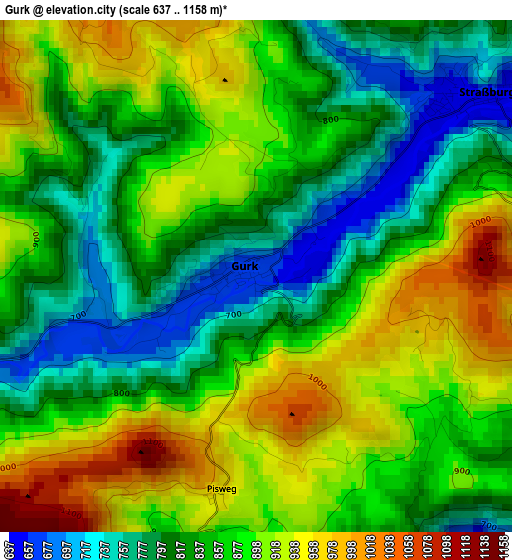
Below is the Elevation map of Gurk, which displays elevation range with different colors. Scale of the first map is from 637 to 1158 m (2090 to 3799 ft) with average elevation of 861.9 meters (=2828 ft) [note 1]
These maps also provides idea of topography and contour of this city, they are displayed at different zoom levels. More info about maps, scale and edge coordinates you can find below images.
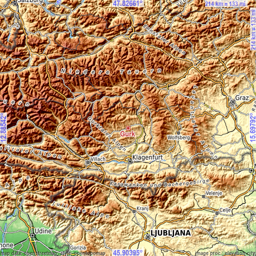
| \ | Map #1 | Topo.Map |
| Scale [m] | 637..1158 m | × |
| Scale [ft] | 2090..3799 ft | × |
| Average | 861.9 m = 2828 ft | × |
| Width | 6.68 km = 4.2 mi | 213.8 km = 132.8 mi |
| Height | 6.68 km = 4.2 mi | 213.8 km = 132.8 mi |
| ↑Max Latitude | 46.903923° | 47.82661° |
| Latitude at center | 46.87389° | 46.87389° |
| ↓Min Latitude | 46.84384° | 45.90395° |
| ← Min Longitude | 14.247725° | 12.88542° |
| Longitude center | 14.29167° | 14.29167° |
| →Max Longitude | 14.335615° | 15.69792° |
Nearby cities:
Cities around Gurk sort by population:
• Sankt Veit an der Glan elevation 485 m
12.9 km,  156°
156°
• Althofen 688 m
13.9 km,  90°
90°
• Friesach 635 m
12.5 km,  43°
43°
• Straßburg-Stadt 647 m
3.6 km,  50°
50°
• Treibach 611 m
13.3 km, 93°
• Micheldorf 773 m
10.6 km,  63°
63°
• Weitensfeld 701 m
8.1 km,  248°
248°
• Metnitz 851 m
13.2 km,  334°
334°
• Glödnitz 747 m
13.1 km,  270°
270°
• Mölbling 570 m
11.1 km,  103°
103°
• Frauenstein 1038 m
6.6 km,  178°
178°
• Micheldorf in Kärnten 626 m
11.3 km,  66°
66°
Multilingual:
 En español:
Gurk elevación 665 m.
 En France:
Gurk élévation 665 m.


Sources and notes:
- [note 1] Map square and city borders are not equal. Map elevation data is calculated only from area inside that square.
- [src 1] Elevation data from geonames database provided with same terms of usage.
- [src 2] The elevation map of Gurk is generated using elevation data from NASA's 3 arcsec (90m) resolution SRTM data.
- [src 3] Base (background) map © OpenStreetMap contributors tiles are generated by Geofabrik and OpenTopoMap.
Copyright & License:
This Gurk Elevation Map is licensed under CC BY-SA. You may reuse any part from this page, if you give a proper credit by linking to this URL:
 More info on terms of use page.