Ötztal-Bahnhof elevation
Ötztal-Bahnhof (Tyrol, Politischer Bezirk Imst), Austria elevation is 722 meters and Ötztal-Bahnhof elevation in feet is 2369 ft above sea level [src 1]. Ötztal-Bahnhof is a populated place (feature code) with elevation that is 213 meters (699 ft) bigger than average city elevation in Austria.
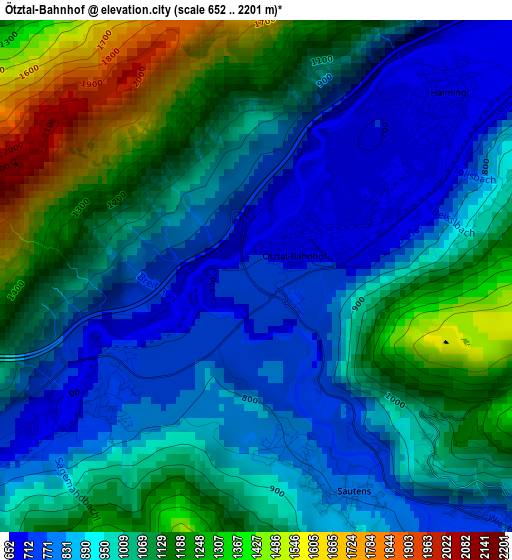
Below is the Elevation map of Ötztal-Bahnhof, which displays elevation range with different colors. Scale of the first map is from 652 to 2201 m (2139 to 7221 ft) with average elevation of 1010.3 meters (=3315 ft) [note 1]
These maps also provides idea of topography and contour of this city, they are displayed at different zoom levels. More info about maps, scale and edge coordinates you can find below images.
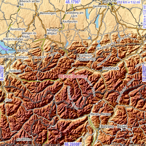
| \ | Map #1 | Topo.Map |
| Scale [m] | 652..2201 m | × |
| Scale [ft] | 2139..7221 ft | × |
| Average | 1010.3 m = 3315 ft | × |
| Width | 6.64 km = 4.1 mi | 212.3 km = 131.9 mi |
| Height | 6.64 km = 4.1 mi | 212.3 km = 131.9 mi |
| ↑Max Latitude | 47.263161° | 48.1796° |
| Latitude at center | 47.23333° | 47.23333° |
| ↓Min Latitude | 47.203482° | 46.26986° |
| ← Min Longitude | 10.806055° | 9.44375° |
| Longitude center | 10.85° | 10.85° |
| →Max Longitude | 10.893945° | 12.25625° |
Nearby cities:
Cities around Ötztal-Bahnhof sort by population:
• Imst elevation 823 m
8.4 km,  278°
278°
• Silz 650 m
7.3 km,  59°
59°
• Haiming 674 m
3.1 km,  53°
53°
• Oetz 786 m
5.3 km,  134°
134°
• Nassereith 842 m
9.4 km,  352°
352°
• Arzl im Pitztal 854 m
7.2 km,  246°
246°
• Tarrenz 816 m
7.3 km,  300°
300°
• Roppen 695 m
3.1 km,  233°
233°
• Sautens 971 m
3.9 km,  161°
161°
• Mötz 728 m
9.4 km, 53°
• Karrösten 905 m
6.4 km,  262°
262°
• Karres 814 m
5.4 km, 249°
Multilingual:
 En español:
Ötztal-Bahnhof elevación 722 m.
 En France:
Ötztal-Bahnhof élévation 722 m.
 Auf Deutsch:
Ötztal-Bahnhof höhe über dem Meeresspiegel ist 722 m.

Sources and notes:
- [note 1] Map square and city borders are not equal. Map elevation data is calculated only from area inside that square.
- [src 1] Elevation data from geonames database provided with same terms of usage.
- [src 2] The elevation map of Ötztal-Bahnhof is generated using elevation data from NASA's 3 arcsec (90m) resolution SRTM data.
- [src 3] Base (background) map © OpenStreetMap contributors tiles are generated by Geofabrik and OpenTopoMap.
Copyright & License:
This Ötztal-Bahnhof Elevation Map is licensed under CC BY-SA. You may reuse any part from this page, if you give a proper credit by linking to this URL:
 More info on terms of use page.