Nassereith elevation
Nassereith (Tyrol, Politischer Bezirk Imst), Austria elevation is 842 meters and Nassereith elevation in feet is 2762 ft above sea level [src 1]. Nassereith is a seat of a third-order administrative division (feature code) with elevation that is 333 meters (1093 ft) bigger than average city elevation in Austria.
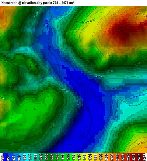
Below is the Elevation map of Nassereith, which displays elevation range with different colors. Scale of the first map is from 794 to 2471 m (2605 to 8107 ft) with average elevation of 1318 meters (=4324 ft) [note 1]
These maps also provides idea of topography and contour of this city, they are displayed at different zoom levels. More info about maps, scale and edge coordinates you can find below images.
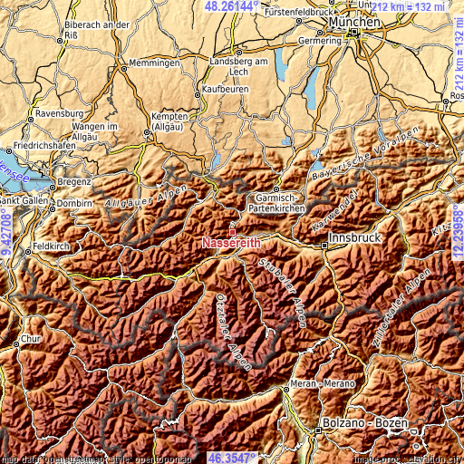
| \ | Map #1 | Topo.Map |
| Scale [m] | 794..2471 m | × |
| Scale [ft] | 2605..8107 ft | × |
| Average | 1318 m = 4324 ft | × |
| Width | 6.63 km = 4.1 mi | 212 km = 131.7 mi |
| Height | 6.63 km = 4.1 mi | 212 km = 131.7 mi |
| ↑Max Latitude | 47.346454° | 48.26144° |
| Latitude at center | 47.31667° | 47.31667° |
| ↓Min Latitude | 47.286869° | 46.3547° |
| ← Min Longitude | 10.789385° | 9.42708° |
| Longitude center | 10.83333° | 10.83333° |
| →Max Longitude | 10.877275° | 12.23958° |
Nearby cities:
Cities around Nassereith sort by population:
• Imst elevation 823 m
10.6 km,  221°
221°
• Ehrwald 973 m
11.2 km,  34°
34°
• Silz 650 m
9.4 km,  126°
126°
• Haiming 674 m
8.3 km,  153°
153°
• Tarrenz 816 m
7.5 km, 222°
• Roppen 695 m
11.2 km,  186°
186°
• Ötztal-Bahnhof 722 m
9.4 km,  172°
172°
• Obsteig 992 m
7.8 km,  103°
103°
• Mötz 728 m
9.5 km,  112°
112°
• Barwies 862 m
10.2 km, 100°
• Lermoos 985 m
10.3 km,  20°
20°
• Biberwier 974 m
9 km, 34°
Multilingual:
 En español:
Nassereith elevación 842 m.
 En France:
Nassereith élévation 842 m.
 Auf Deutsch:
Nassereith höhe über dem Meeresspiegel ist 842 m.

Sources and notes:
- [note 1] Map square and city borders are not equal. Map elevation data is calculated only from area inside that square.
- [src 1] Elevation data from geonames database provided with same terms of usage.
- [src 2] The elevation map of Nassereith is generated using elevation data from NASA's 3 arcsec (90m) resolution SRTM data.
- [src 3] Base (background) map © OpenStreetMap contributors tiles are generated by Geofabrik and OpenTopoMap.
Copyright & License:
This Nassereith Elevation Map is licensed under CC BY-SA. You may reuse any part from this page, if you give a proper credit by linking to this URL:
 More info on terms of use page.